Approximate Location Map
Large Map »
Latitude: 51.3326 / 51°19'57"N
Longitude: 1.4201 / 1°25'12"E
OS Eastings: 638338
OS Northings: 164829
OS Grid: TR383648
Mapcode National: GBR X0L.KT8
Mapcode Global: VHMCW.KRLT
Plus Code: 9F338CMC+22
Entry Name: 29 and 31, Harbour Street
Listing Date: 4 February 1988
Last Amended: 5 January 1990
Grade: II
Source: Historic England
Source ID: 1085382
English Heritage Legacy ID: 171782
ID on this website: 101085382
Location: Ramsgate, Thanet, Kent, CT11
County: Kent
District: Thanet
Civil Parish: Ramsgate
Built-Up Area: Ramsgate
Traditional County: Kent
Lieutenancy Area (Ceremonial County): Kent
Tagged with: Building
In the entry for;
RAMSGATE HARBOUR STREET
TR 3864 NW
13/153 (west side)
GV No. 29
II
The entry shall be amended to read;
TR 3864 NW RAMSGATE HARBOUR STREET
13/153 (west-side)
GV Nos. 29 & 31
II
------------------------------------
RAMSGATE HARBOUR STREET
TR 3864 NW
(west side)
13/153 No. 29
GV II
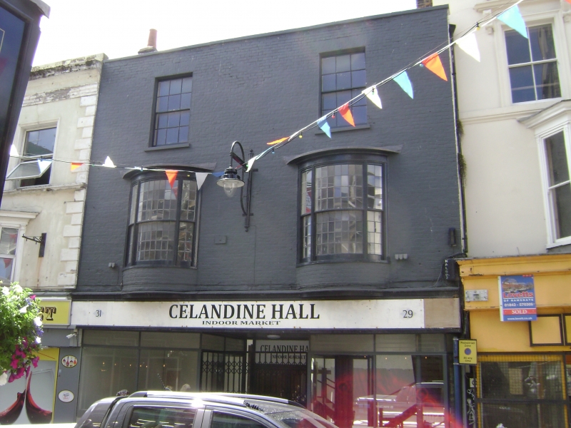
House and shop. Circa 1800, altered mid C20. Painted brick. Three
storeys with parapet and stacks to left and to right. Two glazing bar
sashes on 2nd floor, and 2 leaded sashed shallow bows on 1st floor. Ground
floor with C20 plate glass shop front and central recessed double plate
glass doors. Included for group value.
Listing NGR: TR3833864829
External links are from the relevant listing authority and, where applicable, Wikidata. Wikidata IDs may be related buildings as well as this specific building. If you want to add or update a link, you will need to do so by editing the Wikidata entry.


Other nearby listed buildings
