Latitude: 51.3356 / 51°20'8"N
Longitude: 1.4051 / 1°24'18"E
OS Eastings: 637276
OS Northings: 165120
OS Grid: TR372651
Mapcode National: GBR X0L.814
Mapcode Global: VHMCW.9PNG
Plus Code: 9F338CP4+62
Entry Name: Walls and Gateways Surrounding Nos 136A and B
Listing Date: 4 February 1988
Grade: II
Source: Historic England
Source ID: 1085412
English Heritage Legacy ID: 171753
ID on this website: 101085412
Location: Nethercourt, Thanet, Kent, CT11
County: Kent
District: Thanet
Civil Parish: Ramsgate
Built-Up Area: Ramsgate
Traditional County: Kent
Lieutenancy Area (Ceremonial County): Kent
Tagged with: Wall
RAMSGATE GRANGE ROAD
TR 3765 SW
(west side)
7/123 Walls and
gateways
surrounding
Nos. 136A and B
GV II
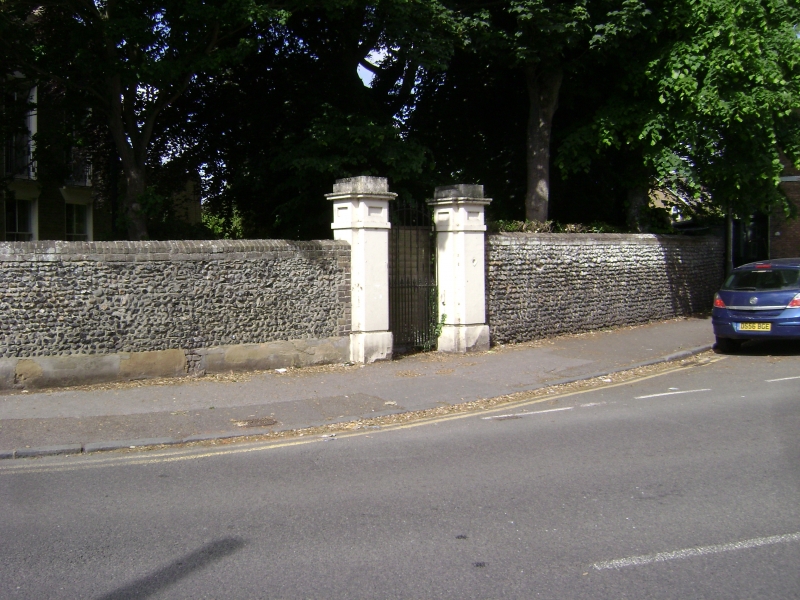
Wall and gateways. Early C19. Flint on rendered base with brick coping,
standing about 6 feet high, ramped up to about 8 feet at north-west
corner, forming a circuit around the grounds of 136A and B Grange Road.
Two gateways, the smaller in east wall with coping to piers, and 2
level railed gate with sun-ray spiked overthrow. Main gate at north-
east corner, the piers with cornices, the gateway without overthrow.
Listing NGR: TR3727665120
External links are from the relevant listing authority and, where applicable, Wikidata. Wikidata IDs may be related buildings as well as this specific building. If you want to add or update a link, you will need to do so by editing the Wikidata entry.


Other nearby listed buildings