Latitude: 51.3307 / 51°19'50"N
Longitude: 1.4145 / 1°24'52"E
OS Eastings: 637956
OS Northings: 164606
OS Grid: TR379646
Mapcode National: GBR X0L.JFV
Mapcode Global: VHMCW.GTM7
Plus Code: 9F338CJ7+7Q
Entry Name: 35 and 37, Addington Street
Listing Date: 4 February 1988
Grade: II
Source: Historic England
Source ID: 1085453
English Heritage Legacy ID: 171659
ID on this website: 101085453
Location: Ramsgate, Thanet, Kent, CT11
County: Kent
District: Thanet
Civil Parish: Ramsgate
Built-Up Area: Ramsgate
Traditional County: Kent
Lieutenancy Area (Ceremonial County): Kent
Tagged with: Building
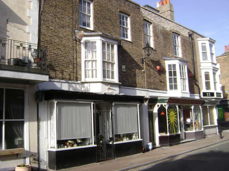
RAMSGATE ADDINGTON STREET TR 3764 NE (west side) 12/30 Nos. 35 and 37 GV II House and shop. Part 1801-21 with late C19 shop front. Stock brick and slate roof. Three storeys with basement, string course to 1st floor and with parapet and stacks to left and to right. Four segmentally headed glazing bar sashes on 2nd floor, 2 canted bays on 1st floor with glazing bar sashes and cornices. C19 shop front to left (37) with bays on simple pillars and-with glazing bars with recessed central doubled half-glazed doors, and panelled door to right with rectangular fanlight. Basement grills in shop bays. Fine late C19 chemist shop front to right with Art Nouveau features, with double canted bay, the piers with heart-shaped brackets to fascia, with glazed tile base. Central recessed half-glazed door with same Art Nouveau tracery as windows. Painted contemporary sign on fascia. Boarded door to left with rectangular fanlight. The building pair is marked on Collard and Hurst's 1821 plan of Ramsgate.
Listing NGR: TR3795664606
External links are from the relevant listing authority and, where applicable, Wikidata. Wikidata IDs may be related buildings as well as this specific building. If you want to add or update a link, you will need to do so by editing the Wikidata entry.


Other nearby listed buildings