Approximate Location Map
Large Map »
Latitude: 51.2373 / 51°14'14"N
Longitude: 1.1258 / 1°7'32"E
OS Eastings: 618294
OS Northings: 153326
OS Grid: TR182533
Mapcode National: GBR TYQ.9G3
Mapcode Global: VHLGV.G5J9
Plus Code: 9F3364PG+W8
Entry Name: Bridge in the Grounds of Bourne Park House
Listing Date: 14 March 1980
Grade: II
Source: Historic England
Source ID: 1085728
English Heritage Legacy ID: 170986
ID on this website: 101085728
Location: Bishopsbourne, Canterbury, Kent, CT4
County: Kent
District: Canterbury
Civil Parish: Bishopsbourne
Traditional County: Kent
Lieutenancy Area (Ceremonial County): Kent
Tagged with: Bridge
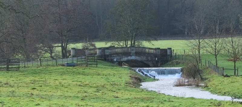
1.
5273 BISHOPSBOURNE BOURNE PARK ROAD
(west side)
Bridge in the grounds of
Bourne Park House
TR 1853 22/132B
II GV
2.
This spans the Nailbourne which feeds the lake in the grounds which was made
in 1847, so the bridge presumably of that date. Red brick. The archway and
the balustrade are faced with Roman cement, the latter in need of repair at
time of survey.
Listing NGR: TR1829453326
External links are from the relevant listing authority and, where applicable, Wikidata. Wikidata IDs may be related buildings as well as this specific building. If you want to add or update a link, you will need to do so by editing the Wikidata entry.


Other nearby listed buildings
