Approximate Location Map
Large Map »
Latitude: 51.4451 / 51°26'42"N
Longitude: 0.2135 / 0°12'48"E
OS Eastings: 553923
OS Northings: 174118
OS Grid: TQ539741
Mapcode National: GBR TN.QHZ
Mapcode Global: VHHNT.NY71
Plus Code: 9F32C6W7+3C
Entry Name: The Royal Oak Public House
Listing Date: 25 September 1975
Grade: II
Source: Historic England
Source ID: 1086036
English Heritage Legacy ID: 172145
Also known as: The Royal Oak, Dartford
Royal Oak
ID on this website: 101086036
Location: Dartford, Kent, DA1
County: Kent
District: Dartford
Electoral Ward/Division: Town
Parish: Non Civil Parish
Built-Up Area: Bexley
Traditional County: Kent
Lieutenancy Area (Ceremonial County): Kent
Church of England Parish: Dartford Holy Trinity
Church of England Diocese: Rochester
Tagged with: Pub
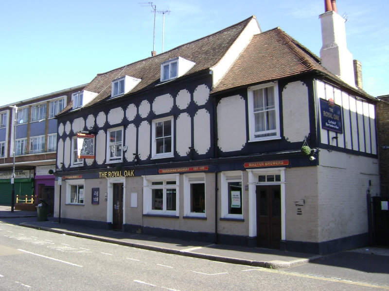
1. SPITAL STREET
5274 (North Side)
No 57 (The Royal Oak
Public House)
TQ 5374 1/57A
II GV
2.
A timber-framed building, probably C17 but refaced in C19. 2 storeys and attics.
Ground floor painted brick, lst floor applied timber-framing with pebbledashed
infill. Tiled roof with 3 dormers. 3 sashes with verticals only. The ground
floor has a C19 pub front. On the right hand side is a C19 portion of 2 storeys
in matching style having one sash with verticals only and a hipped tiled roof.
The interior has exposed beams.
Nos 53 to 57 (odd) form a group.
Listing NGR: TQ5392374122
External links are from the relevant listing authority and, where applicable, Wikidata. Wikidata IDs may be related buildings as well as this specific building. If you want to add or update a link, you will need to do so by editing the Wikidata entry.


Other nearby listed buildings
