Latitude: 51.4451 / 51°26'42"N
Longitude: 0.2119 / 0°12'42"E
OS Eastings: 553809
OS Northings: 174111
OS Grid: TQ538741
Mapcode National: GBR TN.Q2V
Mapcode Global: VHHNT.MYC2
Plus Code: 9F32C6W6+2Q
Entry Name: Twistleton's Almshouses
Listing Date: 25 September 1975
Grade: II
Source: Historic England
Source ID: 1086038
English Heritage Legacy ID: 172150
ID on this website: 101086038
Location: Dartford, Kent, DA1
County: Kent
District: Dartford
Electoral Ward/Division: Town
Parish: Non Civil Parish
Built-Up Area: Bexley
Traditional County: Kent
Lieutenancy Area (Ceremonial County): Kent
Church of England Parish: Dartford Holy Trinity
Church of England Diocese: Rochester
Tagged with: Almshouse
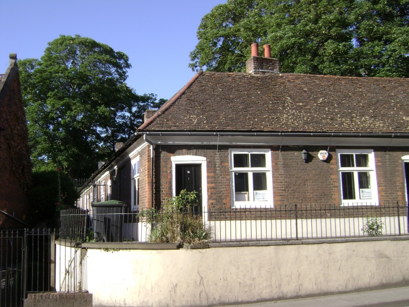
1. WEST HILL
5274 (South Side)
Nos 6 to 22 (even)
(Twistleton's Almshouses)
TQ 5374 1/14
II GV
2.
This charity was founded in 1572 under the will of John Byer of Horsemans Place,
Lowfield, but the existing building was erected by John Twistleton of Horsemans
Place in 1704. L-shaped block of 1 storey red brick. Tiled roof with coved eaves
cornice. Gable ends with kneelers. 4 windows facing north. 6 windows facing
east. Casement windows. Simple wooden doorcases in cambered architraves.
Nos 6 to 22 (even) form a group.
Listing NGR: TQ5380974115
External links are from the relevant listing authority and, where applicable, Wikidata. Wikidata IDs may be related buildings as well as this specific building. If you want to add or update a link, you will need to do so by editing the Wikidata entry.


Other nearby listed buildings