Approximate Location Map
Large Map »
Latitude: 51.3301 / 51°19'48"N
Longitude: 1.4091 / 1°24'32"E
OS Eastings: 637583
OS Northings: 164523
OS Grid: TR375645
Mapcode National: GBR X0L.H32
Mapcode Global: VHMCW.CTSP
Plus Code: 9F338CJ5+3J
Entry Name: Eagle Lodge
Listing Date: 4 February 1988
Grade: II
Source: Historic England
Source ID: 1086047
English Heritage Legacy ID: 172067
ID on this website: 101086047
Location: Ramsgate, Thanet, Kent, CT11
County: Kent
District: Thanet
Civil Parish: Ramsgate
Built-Up Area: Ramsgate
Traditional County: Kent
Lieutenancy Area (Ceremonial County): Kent
Tagged with: Gatehouse
RAMSGATE WEST CLIFF ROAD
TR 3764 NE
(south side)
12/432 No. 50
Eagle Lodge
GV II
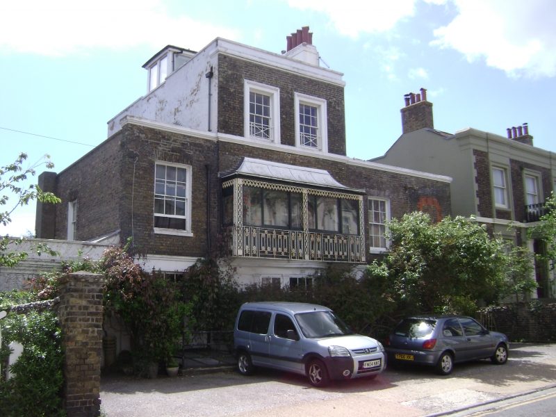
House. Circa 1820. Stock brick with rendered base and slate roof. Three
storey and attic central block with 2 storey flanking wings. Rusticated
base and parapet cornice carried over central block, itself with parapet
and stack to right, and large glazed lantern. Two glazing bar sashes on
2nd floor with diagonal crossed rails, 2 glazing bar sashes and 2
central French windows on first floor with glazed, tented verandah with
pierced wrought iron piers and geometric patterned railings. Glazing
bar sashes to left and to right on ground floor and central bow with 3
glazing bar sashes and entablature on pilasters. Boarded door to left
in 1 storey extension with painted keyed arched surround. Two storey
extension to right with garage doors and blocked window opening over.
The building appears on Collard and Hurst's 1821 map of Ramsgate, and
is there named Cottage Place.
Listing NGR: TR3758364523
External links are from the relevant listing authority and, where applicable, Wikidata. Wikidata IDs may be related buildings as well as this specific building. If you want to add or update a link, you will need to do so by editing the Wikidata entry.


Other nearby listed buildings
