Approximate Location Map
Large Map »
Latitude: 51.3318 / 51°19'54"N
Longitude: 1.4174 / 1°25'2"E
OS Eastings: 638156
OS Northings: 164734
OS Grid: TR381647
Mapcode National: GBR X0L.K4P
Mapcode Global: VHMCW.JS6F
Plus Code: 9F338CJ8+PX
Entry Name: 5, Rose Hill
Listing Date: 4 February 1988
Grade: II
Source: Historic England
Source ID: 1086086
English Heritage Legacy ID: 171975
ID on this website: 101086086
Location: Ramsgate, Thanet, Kent, CT11
County: Kent
District: Thanet
Civil Parish: Ramsgate
Built-Up Area: Ramsgate
Traditional County: Kent
Lieutenancy Area (Ceremonial County): Kent
Tagged with: Building
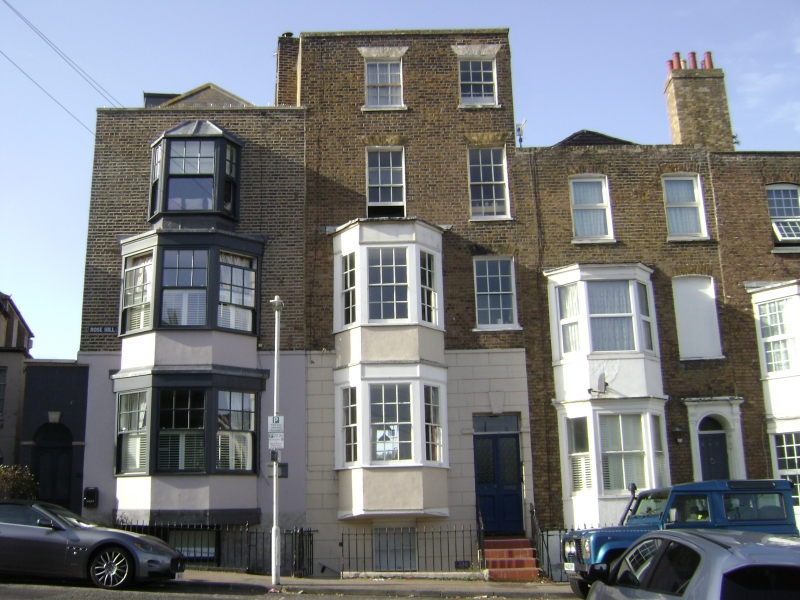
RAMSGATE ROSE HILL
TR 3864 NW
(west side)
13/339 No. 5
GV II
House. Circa 1800, altered mid C19. Stock brick, part rendered. Four
storeys and basement with rusticated base and parapet with stack to left.
Two glazing bar sashes to 3rd and 2nd floors, with wooden casement to
right on 1st floor. Two storey canted bay to 1st and ground floors, with
sashes. Half glazed and panelled door to right with rectangular fanlight
in keyed surround, with 4 steps. Glazing bar sash to basement. Shown on
Collard and Hurst's 1822 map and first rated c.1798. (Busson, Ramsgate,
108).
Listing NGR: TR3815664734
External links are from the relevant listing authority and, where applicable, Wikidata. Wikidata IDs may be related buildings as well as this specific building. If you want to add or update a link, you will need to do so by editing the Wikidata entry.


Other nearby listed buildings
