Approximate Location Map
Large Map »
Latitude: 51.276 / 51°16'33"N
Longitude: 0.5745 / 0°34'28"E
OS Eastings: 579667
OS Northings: 156131
OS Grid: TQ796561
Mapcode National: GBR PR3.VFT
Mapcode Global: VHJMF.X625
Plus Code: 9F327HGF+9R
Entry Name: 30-36, Ware Street
Listing Date: 20 July 1984
Grade: II
Source: Historic England
Source ID: 1086172
English Heritage Legacy ID: 173726
ID on this website: 101086172
Location: Ware Street, Maidstone, Kent, ME14
County: Kent
District: Maidstone
Civil Parish: Bearsted
Built-Up Area: Maidstone
Traditional County: Kent
Lieutenancy Area (Ceremonial County): Kent
Tagged with: Building
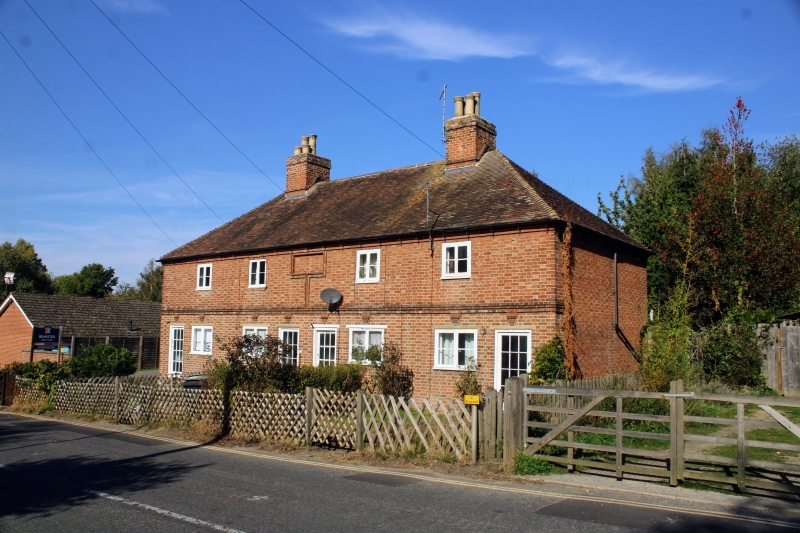
TQ 75 NE THURNHAM WARE STREET
(north side)
5/219 Nos. 30-36, (Even)
GV II
Possible almshouse row, now cottage row. Late C18 or early C19.
Red brick in Flemish bond with occasional grey brick header.
Plain tile roof. Double depth plan. Two storeys on stone plinth.
Moulded band, carried up vertically at centre of first floor
to surround a plain rectangular recess under eaves. Moulded brick
eaves cornice. Roof hipped at both ends with hips continued along
side elevations. Brick ridge stack towards either end. Regular
four window front of widely-spaced two-light casements. Four
C20 half-glazed doors, two to centre and one to each end.
Listing NGR: TQ7940956467
External links are from the relevant listing authority and, where applicable, Wikidata. Wikidata IDs may be related buildings as well as this specific building. If you want to add or update a link, you will need to do so by editing the Wikidata entry.


Other nearby listed buildings
