Approximate Location Map
Large Map »
Latitude: 51.2709 / 51°16'15"N
Longitude: 0.5878 / 0°35'16"E
OS Eastings: 580612
OS Northings: 155600
OS Grid: TQ806556
Mapcode National: GBR PR9.CDD
Mapcode Global: VHJMG.4BL1
Plus Code: 9F327HCQ+94
Entry Name: Pump Immediately West of Junction with Sutton Street
Listing Date: 20 July 1984
Grade: II
Source: Historic England
Source ID: 1086268
English Heritage Legacy ID: 173542
ID on this website: 101086268
Location: Maidstone, Kent, ME14
County: Kent
District: Maidstone
Civil Parish: Bearsted
Built-Up Area: Maidstone
Traditional County: Kent
Lieutenancy Area (Ceremonial County): Kent
Tagged with: Building
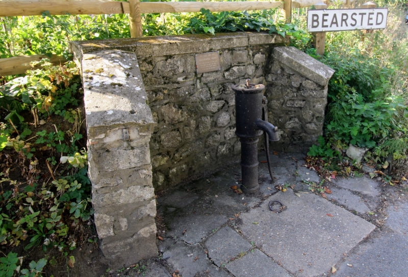
TQ 85 NW BEARSTED ROUNDWELL
(south side)
6/35
Pump immediately
west of junction
with Sutton Street
II
Hand pump. Circa 1800. Iron with handle to right and spout
to front. Plain domed top. The only public water supply
in this part of Bearsted until 1926.
Listing NGR: TQ8061255600
External links are from the relevant listing authority and, where applicable, Wikidata. Wikidata IDs may be related buildings as well as this specific building. If you want to add or update a link, you will need to do so by editing the Wikidata entry.


Other nearby listed buildings
