Approximate Location Map
Large Map »
Latitude: 51.2734 / 51°16'24"N
Longitude: 0.5222 / 0°31'19"E
OS Eastings: 576027
OS Northings: 155718
OS Grid: TQ760557
Mapcode National: GBR PR7.0VW
Mapcode Global: VHJMF.08D4
Plus Code: 9F327GFC+9V
Entry Name: The Town Hall
Listing Date: 30 July 1951
Grade: II*
Source: Historic England
Source ID: 1086305
English Heritage Legacy ID: 173423
ID on this website: 101086305
Location: Maidstone, Kent, ME14
County: Kent
District: Maidstone
Electoral Ward/Division: High Street
Parish: Non Civil Parish
Built-Up Area: Maidstone
Traditional County: Kent
Lieutenancy Area (Ceremonial County): Kent
Tagged with: City hall Seat of local government
MIDDLE ROW
1.
5278
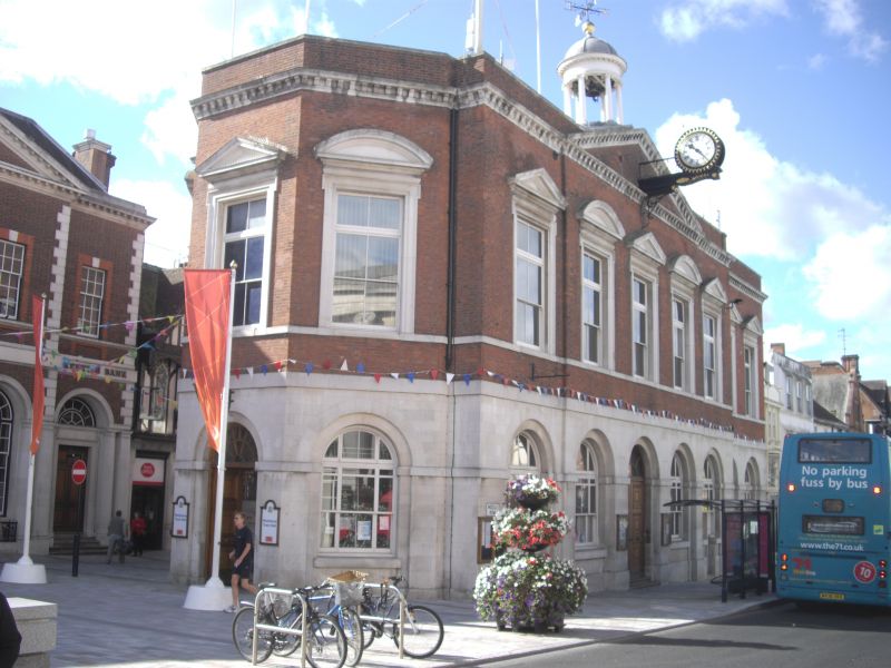
The Town Hall
TQ 7655 NW 2/21 30.7.51.
II*
2.
Built 1762-3. The ground floor was originally used as a market, then converted
into the police court. 2 storeys. 7 windows, the easternmost and westernmost
ones slightly set back. Ground floor Portland ashlar above red brick with
stone dressings. Stone modillion cornice and brick parapet with pediment,
above the 3 easternmost windows of the non-recessed portion. Cupola of 8
Ionic columns supporting a small dome surmounted by a gilded ball and weather
vane. 1st floor windows in stone architrave surrounds with pediments over,
alternately triangular and curved. Large round-headed windows on the ground
floor flanked by pilasters, with a stringcourse above the ground floor. 2
round-headed doorways with large semi-circular fanlights and doors of 6 moulded
panels. The east end of the building forms a canted bay of 3 windows. The
Council Chamber contains a fine Rococo painted ceiling and drops of musical
instruments on the wall by Galli and Cotti. 2 C18 pedimented overmantels,
and 6 fielded panelled doors. There are also 2 large cells with graffiti carved
by the prisoners. This was used as a prison before the prison along Boxley
Road was built and incorporates timbers from an earlier timber-framed building
on the site.
Listing NGR: TQ7602755719
External links are from the relevant listing authority and, where applicable, Wikidata. Wikidata IDs may be related buildings as well as this specific building. If you want to add or update a link, you will need to do so by editing the Wikidata entry.


Other nearby listed buildings
