Approximate Location Map
Large Map »
Latitude: 51.2732 / 51°16'23"N
Longitude: 0.522 / 0°31'19"E
OS Eastings: 576017
OS Northings: 155688
OS Grid: TQ760556
Mapcode National: GBR PR7.0SS
Mapcode Global: VHJMF.08BB
Plus Code: 9F327GFC+7R
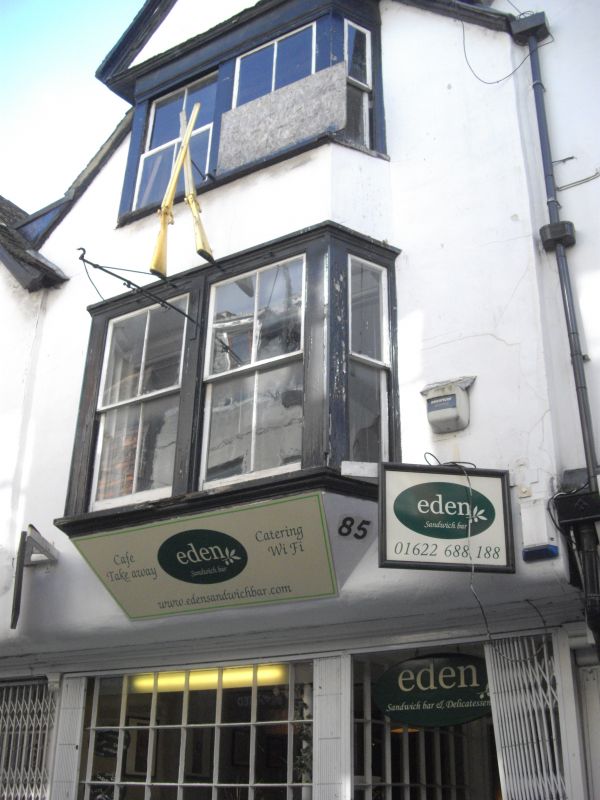
Entry Name: 85, BANK STREET (See details for further address information)
Listing Date: 30 July 1951
Grade: II*
Source: Historic England
Source ID: 1086357
English Heritage Legacy ID: 173362
ID on this website: 101086357
Location: Maidstone, Kent, ME14
County: Kent
District: Maidstone
Electoral Ward/Division: High Street
Parish: Non Civil Parish
Built-Up Area: Maidstone
Traditional County: Kent
Lieutenancy Area (Ceremonial County): Kent
Tagged with: Building
HIGH STREET
1.
5278
BANK STREET
(South-East Side)
No 85
TQ 7655 NW 2/284 30.7.51.
11* GV
2.
A timber-framed building refronted. 3 storeys stuccoed with overhang. Tiled
roof. Gable fronted. 1 4-light bay through all upper floors with verticals
only. Early C19 shopfront with panelled risers. 2 golden crossed guns shop
sign.
Nos 73 to 88 (consec) form a group.
Listing NGR: TQ7601955683
External links are from the relevant listing authority and, where applicable, Wikidata. Wikidata IDs may be related buildings as well as this specific building. If you want to add or update a link, you will need to do so by editing the Wikidata entry.


Other nearby listed buildings
