Approximate Location Map
Large Map »
Latitude: 51.2548 / 51°15'17"N
Longitude: 0.5036 / 0°30'12"E
OS Eastings: 574802
OS Northings: 153599
OS Grid: TQ748535
Mapcode National: GBR PRD.84T
Mapcode Global: VHJMD.PQ3G
Plus Code: 9F327G33+WC
Entry Name: Dean Farmhouse
Listing Date: 2 August 1974
Grade: II
Source: Historic England
Source ID: 1086368
English Heritage Legacy ID: 173287
ID on this website: 101086368
Location: Dean Street, Maidstone, Kent, ME15
County: Kent
District: Maidstone
Civil Parish: East Farleigh
Traditional County: Kent
Lieutenancy Area (Ceremonial County): Kent
Church of England Parish: East Farleigh
Church of England Diocese: Rochester
Tagged with: Farmhouse
DEAN STREET
1.
5278
(East Side)
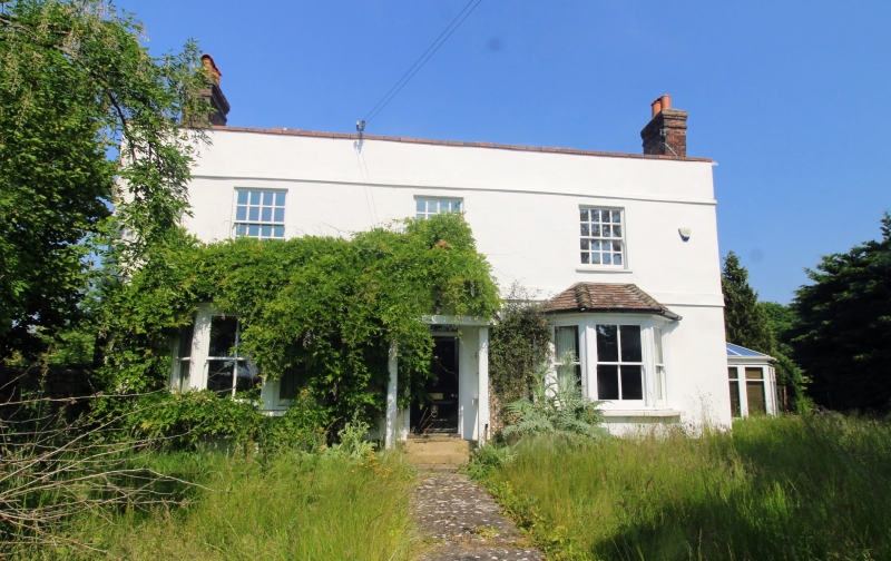
Dean Farmhouse
TQ 75 SW 10/235
II GV
2.
Early to mid C19. 2 storeys pebble dashed. Hipped tiled roof. Parapet and
stone coping. 3 sashes with verticals only. 2 3-light ground floor bays and
C19 hipped weather porch.
Dean Farmhouse and Barn to the south of Dean Farmhouse form a group.
Listing NGR: TQ7617455579
External links are from the relevant listing authority and, where applicable, Wikidata. Wikidata IDs may be related buildings as well as this specific building. If you want to add or update a link, you will need to do so by editing the Wikidata entry.


Other nearby listed buildings
