Latitude: 54.2009 / 54°12'3"N
Longitude: -2.9547 / 2°57'16"W
OS Eastings: 337818
OS Northings: 478771
OS Grid: SD378787
Mapcode National: GBR 7MTV.3V
Mapcode Global: WH83C.LN6W
Plus Code: 9C6V622W+94
Entry Name: Cross and Fish Stone
Listing Date: 25 March 1970
Last Amended: 15 February 1989
Grade: II
Source: Historic England
Source ID: 1087167
English Heritage Legacy ID: 77002
ID on this website: 101087167
Location: Cartmel, Westmorland and Furness, Cumbria, LA11
County: Cumbria
District: South Lakeland
Civil Parish: Lower Allithwaite
Traditional County: Lancashire
Lieutenancy Area (Ceremonial County): Cumbria
Church of England Parish: Cartmel St Mary and St Michael
Church of England Diocese: Carlisle
Tagged with: Building High cross
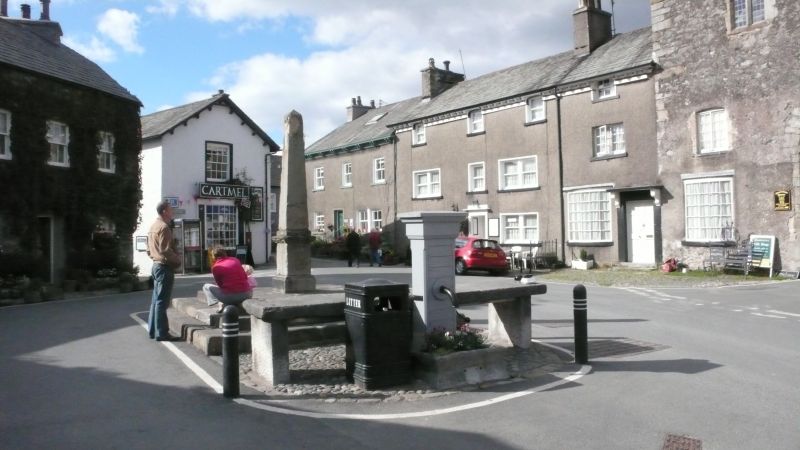
LOWER ALLITHWAITE THE SQUARE
SD 3778
Cartmel
8/88 Cross and Fish Stone
25..3.70 (formerly listed as Market
Cross, Village Pump and
Fish Slab)
G.V. II
Obelisk, bench and pump. Stone. C18. 3 square steps with obelisk on plinth,
fish stone to east comprises 2 slabs on flat uprights. Pump attached to east
has C2O wood casing and stone trough. Obelisk on site of medieval cross. Fish
stone used for sale of fish.
Listing NGR: SD3781978771
External links are from the relevant listing authority and, where applicable, Wikidata. Wikidata IDs may be related buildings as well as this specific building. If you want to add or update a link, you will need to do so by editing the Wikidata entry.


Other nearby listed buildings