Approximate Location Map
Large Map »
Latitude: 54.9531 / 54°57'11"N
Longitude: -2.7623 / 2°45'44"W
OS Eastings: 351279
OS Northings: 562320
OS Grid: NY512623
Mapcode National: GBR 9C45.S7
Mapcode Global: WH7ZS.JRVQ
Plus Code: 9C6VX63Q+73
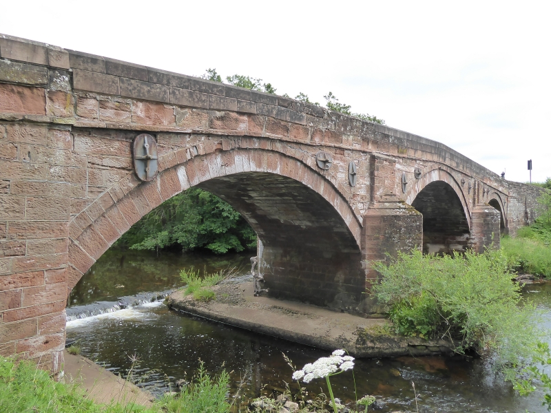
Entry Name: Irthing Bridge
Listing Date: 16 January 1984
Grade: II
Source: Historic England
Source ID: 1087659
English Heritage Legacy ID: 77791
ID on this website: 101087659
Location: Cumberland, Cumbria, CA8
County: Cumbria
District: Carlisle
Civil Parish: Brampton
Traditional County: Cumberland
Lieutenancy Area (Ceremonial County): Cumbria
Church of England Parish: Brampton St Martin
Church of England Diocese: Carlisle
Tagged with: Bridge
NY 56 SW BRAMPTON A6071 (North
west of Brampton)
10/77 Irthing Bridge
II
Road Bridge over the River Irthing. Probably 1729, with alterations for the
Brampton - Longtown Turnpike Trust, formed 1807. Dressed red sandstone. 3
arched bridge on 2 piers with splayed cut-waters, humped back and of single
track width.
Listing NGR: NY5127962320
External links are from the relevant listing authority and, where applicable, Wikidata. Wikidata IDs may be related buildings as well as this specific building. If you want to add or update a link, you will need to do so by editing the Wikidata entry.


Other nearby listed buildings
