Approximate Location Map
Large Map »
Latitude: 54.9419 / 54°56'30"N
Longitude: -2.735 / 2°44'6"W
OS Eastings: 353009
OS Northings: 561055
OS Grid: NY530610
Mapcode National: GBR 9CB9.N7
Mapcode Global: WH7ZZ.Y1RR
Plus Code: 9C6VW7R7+QX
Entry Name: Post Office
Listing Date: 16 January 1984
Grade: II
Source: Historic England
Source ID: 1087672
English Heritage Legacy ID: 77820
ID on this website: 101087672
Location: Brampton, Cumberland, Cumbria, CA8
County: Cumbria
District: Carlisle
Civil Parish: Brampton
Built-Up Area: Brampton
Traditional County: Cumberland
Lieutenancy Area (Ceremonial County): Cumbria
Church of England Parish: Brampton St Martin
Church of England Diocese: Carlisle
Tagged with: Post office
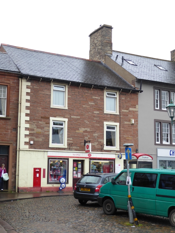
NY 5361 BRAMPTON FRONT STREET
BRAMPTON (South side)
16/26 No 5 (Post Office)
G.V. II
Post office, formerly house. Early C19. Dressed red and yellow sandstone,
ashlar to ground floor and raised quoins to left only, Welsh slate roof with
yellow brick chimney stack. C20 shop windows and doors. C20 2-pane casements
above have painted stone surrounds. Included for group value.
Listing NGR: NY5301161047
External links are from the relevant listing authority and, where applicable, Wikidata. Wikidata IDs may be related buildings as well as this specific building. If you want to add or update a link, you will need to do so by editing the Wikidata entry.


Other nearby listed buildings
