Approximate Location Map
Large Map »
Latitude: 53.3018 / 53°18'6"N
Longitude: -1.4678 / 1°28'3"W
OS Eastings: 435566
OS Northings: 378450
OS Grid: SK355784
Mapcode National: GBR LZ68.13
Mapcode Global: WHDF2.F89L
Plus Code: 9C5W8G2J+PV
Entry Name: Rose Hill and Attached Boundary Walls
Listing Date: 9 January 1967
Last Amended: 7 July 1989
Grade: II
Source: Historic England
Source ID: 1087773
English Heritage Legacy ID: 79532
ID on this website: 101087773
Location: Dronfield, North East Derbyshire, S18
County: Derbyshire
District: North East Derbyshire
Civil Parish: Dronfield
Built-Up Area: Dronfield
Traditional County: Derbyshire
Lieutenancy Area (Ceremonial County): Derbyshire
Church of England Parish: Dronfield St John Baptist
Church of England Diocese: Derby
Tagged with: Building
PARISH OF DRONFIELD PRINCESS ROAD
SK 37 NE
6/51
Rose Hill and attached
9.1.67 boundary walls
(formerly listed as
Rose Hill (No 57)
II
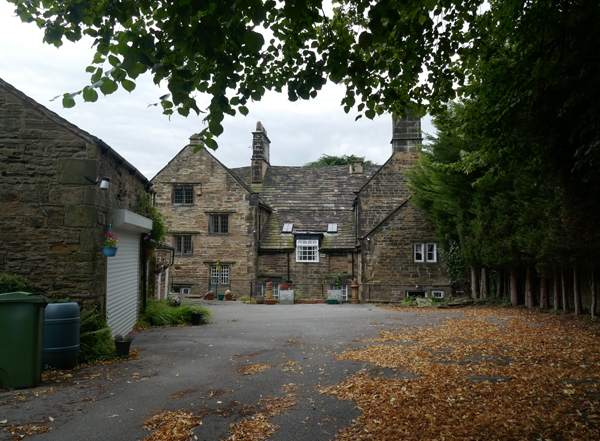
House. Mid C17, with remodelling in 1719, and additions in C19.
Coursed coal measures sandstone with quoins, coped gables with
moulded kneelers, ashlar gable and ridge stacks and a stone
slated roof. Asymmetrical plan, with three bay central range,
two contemporary gabled wings to rear, with C19 infill between
them and additions to the end of the western rear ring. South
elevation; three storeys, four bays, a former three gabled front
now remodelled to form a parapet linking the outer gables.
Stacked chamfer mullioned windows to outer gables and above
central doorway beneath continuous stringcourses with label
stops, now with many mullions removed, and with C20 casements.
Ground floor openings formerly 5-lights, first and second
openings 4-lights, the stringcourse to the second floor stepped
up above the window heads. Outer gables with C17 single light
openings to gable apex below a dripmould. Added parapet with
shallow pilasters adjoining the gables, and with open central
part which has turned balusters and moulded copings. Between
the centre bay and the easter end gable, at ground and first
floor level, single light C17 windows. Off-centre doorway with
quoined surround, substantial lintel and semi-circular pediment.
East and west gables and gable to east rear range with 2 and
3-light chamfer mullioned windows beneath dripmoulds. Addition
to west rear range with 2-light flush mullioned windows.
Interior. Full height splat baluster stair, some moulded
plasterwork to principal ground floor rooms. Two rooms have C18
panelling, and some C17 panelled doors. Attached boundary walls
of coursed rubble sandstone and plain stone copings steps
downwards as land falls away to south, incorporating tall ashlar
gatepiers, square in plan with moulded cornice and ball finials.
The house was described in sale papers in 1725 as 'newly
erected'.
Listing NGR: SK3556678450
External links are from the relevant listing authority and, where applicable, Wikidata. Wikidata IDs may be related buildings as well as this specific building. If you want to add or update a link, you will need to do so by editing the Wikidata entry.


Other nearby listed buildings
