Latitude: 53.3765 / 53°22'35"N
Longitude: -1.9921 / 1°59'31"W
OS Eastings: 400622
OS Northings: 386632
OS Grid: SK006866
Mapcode National: GBR GYJD.JB
Mapcode Global: WHBB5.CDM9
Plus Code: 9C5W92G5+J5
Entry Name: 31, Batemill Road
Listing Date: 19 September 1977
Grade: II
Source: Historic England
Source ID: 1088132
English Heritage Legacy ID: 81812
ID on this website: 101088132
Location: Thornsett, High Peak, Derbyshire, SK22
County: Derbyshire
District: High Peak
Civil Parish: New Mills
Traditional County: Derbyshire
Lieutenancy Area (Ceremonial County): Derbyshire
Church of England Parish: New Mills St George
Church of England Diocese: Derby
Tagged with: Building
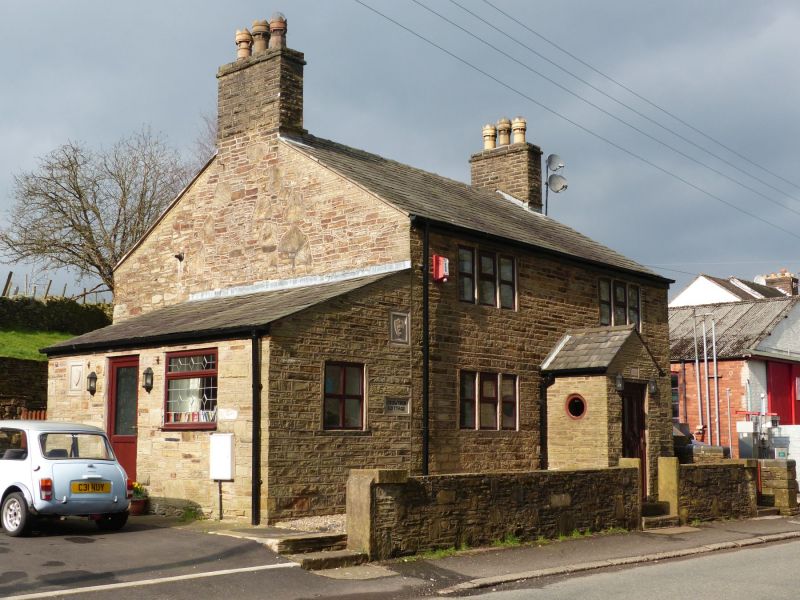
NEW MILLS BATEMILL ROAD
1.
5172
(West Side)
SK 08 NW 4/98 No 31
II
2.
C18 stone cottage of 2 storeys in coursed stone with stone slate roof with stacks
at gable ends. 2 windows of 3 lights, stone mullions and surrounds on 2 floors.
Modern stone porch. Penticed extension with doorway to left.
Listing NGR: SK0062286632
External links are from the relevant listing authority and, where applicable, Wikidata. Wikidata IDs may be related buildings as well as this specific building. If you want to add or update a link, you will need to do so by editing the Wikidata entry.


Other nearby listed buildings