Approximate Location Map
Large Map »
Latitude: 53.2532 / 53°15'11"N
Longitude: -1.3931 / 1°23'35"W
OS Eastings: 440588
OS Northings: 373079
OS Grid: SK405730
Mapcode National: GBR LZQT.6J
Mapcode Global: WHDF9.KHTD
Plus Code: 9C5W7J34+7Q
Entry Name: Street Boundary Wall and Gatepiers at the Manor House
Listing Date: 26 September 1977
Grade: II
Source: Historic England
Source ID: 1088253
English Heritage Legacy ID: 83408
ID on this website: 101088253
Location: Brimington, Chesterfield, Derbyshire, S43
County: Derbyshire
District: Chesterfield
Civil Parish: Brimington
Built-Up Area: Chesterfield
Traditional County: Derbyshire
Lieutenancy Area (Ceremonial County): Derbyshire
Church of England Parish: Brimington St Michael and All Angels
Church of England Diocese: Derby
Tagged with: Wall
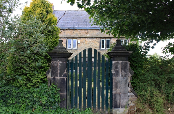
MANOR ROAD
1.
5169 (West Side)
Brimington
Street boundary wall
and gatepiers at
The Manor House
SK 4073 10/78A
II GV
2.
C17. Tall ashlar gatepiers with cornices and ball finials on pedestals. Front
stone garden wall ramped up to gate piers,
Listing NGR: SK4058873079
External links are from the relevant listing authority and, where applicable, Wikidata. Wikidata IDs may be related buildings as well as this specific building. If you want to add or update a link, you will need to do so by editing the Wikidata entry.


Other nearby listed buildings
