Approximate Location Map
Large Map »
Latitude: 53.2366 / 53°14'11"N
Longitude: -1.4242 / 1°25'27"W
OS Eastings: 438525
OS Northings: 371212
OS Grid: SK385712
Mapcode National: GBR 698.0RL
Mapcode Global: WHDF9.3X15
Plus Code: 9C5W6HPG+J8
Entry Name: War Memorial in Churchyard to North East of St Mary's Church
Listing Date: 9 August 1976
Grade: II
Source: Historic England
Source ID: 1088272
English Heritage Legacy ID: 83448
ID on this website: 101088272
Location: St Mary and All Saints Church, Chesterfield, Derbyshire, S40
County: Derbyshire
District: Chesterfield
Electoral Ward/Division: St Leonard's
Parish: Non Civil Parish
Built-Up Area: Chesterfield
Traditional County: Derbyshire
Lieutenancy Area (Ceremonial County): Derbyshire
Church of England Parish: Chesterfield St Mary and All Saints
Church of England Diocese: Derby
Tagged with: War memorial
ST MARY'S GATE
1.
5169 (West Side)
War Memorial in churchyard
to north-east of
St Mary's Church
SK 3871 SW 1/126 9.8.76.
II
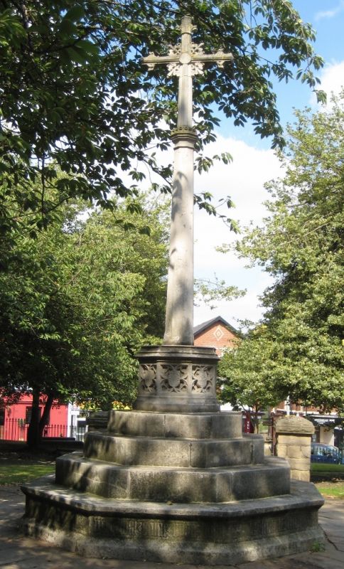
2.
Earlier C20 War Memorial of white stone. Tall tapering stone crucifix rises from
octagonal plinth with 4 steps, the first 1 with band of lettering. Carving and
shields above octagonal base.
Listing NGR: SK3852571212
This List entry has been amended to add sources for War Memorials Online and the War Memorials Register. These sources were not used in the compilation of this List entry but are added here as a guide for further reading, 25 January 2017.
External links are from the relevant listing authority and, where applicable, Wikidata. Wikidata IDs may be related buildings as well as this specific building. If you want to add or update a link, you will need to do so by editing the Wikidata entry.


Other nearby listed buildings
