Approximate Location Map
Large Map »
Latitude: 53.2352 / 53°14'6"N
Longitude: -1.4279 / 1°25'40"W
OS Eastings: 438284
OS Northings: 371063
OS Grid: SK382710
Mapcode National: GBR 697.5T4
Mapcode Global: WHDF9.1YB5
Plus Code: 9C5W6HPC+3V
Entry Name: 4, Central Pavement
Listing Date: 9 August 1976
Grade: II
Source: Historic England
Source ID: 1088297
English Heritage Legacy ID: 83313
ID on this website: 101088297
Location: Chesterfield, Derbyshire, S40
County: Derbyshire
District: Chesterfield
Electoral Ward/Division: St Leonard's
Parish: Non Civil Parish
Built-Up Area: Chesterfield
Traditional County: Derbyshire
Lieutenancy Area (Ceremonial County): Derbyshire
Church of England Parish: Chesterfield St Mary and All Saints
Church of England Diocese: Derby
Tagged with: Building
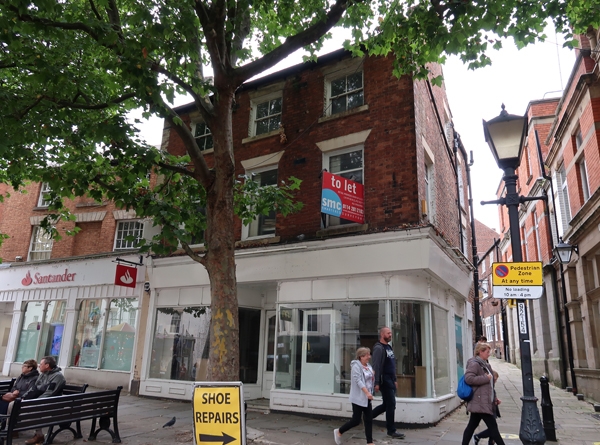
CENTRAL PAVEMENT
1.
5169 (North Side)
No 4
SK 3871 SW 1/84 9.8.76.
II GV
2.
Late C18/early C19. Red brick with moulded wooden eaves cornice and slate roof
with end chimneys. 3 storeys. 3 windows, those of second floor unbarred sashes,
1st floor modern glazing in former sash spaces, stuccoed lintels. Ground floor
has late C19/early C20 shop front retaining cornice and end consoles, modern fascia
board and shop windows.
Listing NGR: SK3828471063
External links are from the relevant listing authority and, where applicable, Wikidata. Wikidata IDs may be related buildings as well as this specific building. If you want to add or update a link, you will need to do so by editing the Wikidata entry.


Other nearby listed buildings
