Approximate Location Map
Large Map »
Latitude: 53.235 / 53°14'5"N
Longitude: -1.428 / 1°25'40"W
OS Eastings: 438277
OS Northings: 371037
OS Grid: SK382710
Mapcode National: GBR 697.CS4
Mapcode Global: WHDF9.1Y9C
Plus Code: 9C5W6HMC+XR
Entry Name: 1 and 1A, Low Pavement
Listing Date: 9 August 1976
Grade: II
Source: Historic England
Source ID: 1334675
English Heritage Legacy ID: 83387
ID on this website: 101334675
Location: Chesterfield, Derbyshire, S40
County: Derbyshire
District: Chesterfield
Electoral Ward/Division: St Leonard's
Parish: Non Civil Parish
Built-Up Area: Chesterfield
Traditional County: Derbyshire
Lieutenancy Area (Ceremonial County): Derbyshire
Church of England Parish: Chesterfield St Mary and All Saints
Church of England Diocese: Derby
Tagged with: Building
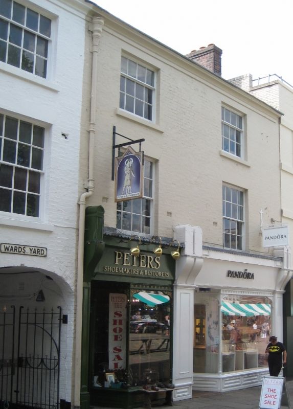
1.
5169
SK 3871 SW
1/86
9.8.76
LOW PAVEMENT
Nos 1 and 1A
II
GV
2.
Late C18/early C19 facade. Painted brick with moulded eaves cornice. Slate roof
with end chimneys. 3 storeys. 2 windows, sashes with stuccoed lintels the top
half of each window has glazing bars. Ground floor has 2 shop fronts with cornice
and end consoles. Those of No 1 paired with mirror bands below in place of pilasters.
Eastern side door with rectangular fanlight. No 1A also has eastern side door.
Listing NGR: SK3827771037
External links are from the relevant listing authority and, where applicable, Wikidata. Wikidata IDs may be related buildings as well as this specific building. If you want to add or update a link, you will need to do so by editing the Wikidata entry.


Other nearby listed buildings
