Approximate Location Map
Large Map »
Latitude: 51.6373 / 51°38'14"N
Longitude: -2.1579 / 2°9'28"W
OS Eastings: 389166
OS Northings: 193173
OS Grid: ST891931
Mapcode National: GBR 1P0.789
Mapcode Global: VH95K.K31Q
Plus Code: 9C3VJRPR+WR
Entry Name: 14 and 16, Gumstool Hill
Listing Date: 21 March 1985
Grade: II
Source: Historic England
Source ID: 1089610
English Heritage Legacy ID: 128508
ID on this website: 101089610
Location: Tetbury, Cotswold, Gloucestershire, GL8
County: Gloucestershire
District: Cotswold
Civil Parish: Tetbury
Built-Up Area: Tetbury
Traditional County: Gloucestershire
Lieutenancy Area (Ceremonial County): Gloucestershire
Church of England Parish: Tetbury St Mary the Virgin
Church of England Diocese: Gloucester
Tagged with: Building
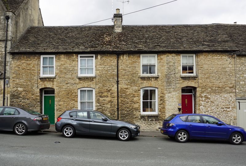
ST 8893-8993 TETBURY GUMSTOOL HILL
(west side)
7/234 Nos 14 and 16
GV II
Pair of cottages in terrace. Mid C19. Coursed and snecked rubble
stone with Cotswold stone slate roof and central stone ridge stack.
Single range. 2 storeys. 2 windows each, and one on ground floor.
All 4-pane sashes, with cambered heads on ground floor. Cambered
head recessed doorway to left with original 4-panel doors and plain
rectangular fanlights. Included for group value with Nos. 2-28
(even) Gumstool Hill (q.v.).
Listing NGR: ST8916893177
External links are from the relevant listing authority and, where applicable, Wikidata. Wikidata IDs may be related buildings as well as this specific building. If you want to add or update a link, you will need to do so by editing the Wikidata entry.


Other nearby listed buildings
