Approximate Location Map
Large Map »
Latitude: 51.637 / 51°38'13"N
Longitude: -2.1578 / 2°9'28"W
OS Eastings: 389175
OS Northings: 193149
OS Grid: ST891931
Mapcode National: GBR 1P0.79G
Mapcode Global: VH95K.K33W
Plus Code: 9C3VJRPR+RV
Entry Name: 1, Gumstool Hill
Listing Date: 6 September 1954
Grade: II
Source: Historic England
Source ID: 1089608
English Heritage Legacy ID: 128504
ID on this website: 101089608
Location: Tetbury, Cotswold, Gloucestershire, GL8
County: Gloucestershire
District: Cotswold
Civil Parish: Tetbury
Built-Up Area: Tetbury
Traditional County: Gloucestershire
Lieutenancy Area (Ceremonial County): Gloucestershire
Church of England Parish: Tetbury St Mary the Virgin
Church of England Diocese: Gloucester
Tagged with: Building
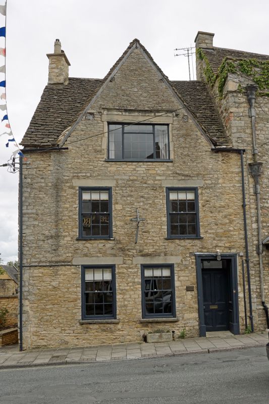
ST 8893-8993 TETBURY GUMSTOOL HILL
(east side)
7/230 No 1
6.9.54
GV II
House. Mid/late C17. Rubble stone, Cotswold stone slate roof to
front, tile to left side, 2 rendered gable stacks to left. Long
range with gable to street and 2 cross gables. 3 storeys. 2
windows, renewed 12-pane sashes with moulded wood architraves and
concrete lintels. Ground floor has 2 similar and doorway to right
with deep panelled reveal and 4-panel bolection-moulded door.
Gable has wide C20 metal window inserted under original square hood
mould.
Listing NGR: ST8917593149
External links are from the relevant listing authority and, where applicable, Wikidata. Wikidata IDs may be related buildings as well as this specific building. If you want to add or update a link, you will need to do so by editing the Wikidata entry.


Other nearby listed buildings
