Approximate Location Map
Large Map »
Latitude: 51.6356 / 51°38'8"N
Longitude: -2.1642 / 2°9'51"W
OS Eastings: 388731
OS Northings: 192994
OS Grid: ST887929
Mapcode National: GBR 1NZ.KMT
Mapcode Global: VH95K.F4QY
Plus Code: 9C3VJRPP+78
Entry Name: Cutwell Bridge
Listing Date: 21 March 1985
Grade: II
Source: Historic England
Source ID: 1089644
English Heritage Legacy ID: 128484
ID on this website: 101089644
Location: Tetbury, Cotswold, Gloucestershire, GL8
County: Gloucestershire
District: Cotswold
Civil Parish: Tetbury
Built-Up Area: Tetbury
Traditional County: Gloucestershire
Lieutenancy Area (Ceremonial County): Gloucestershire
Church of England Parish: Tetbury St Mary the Virgin
Church of England Diocese: Gloucester
Tagged with: Bridge
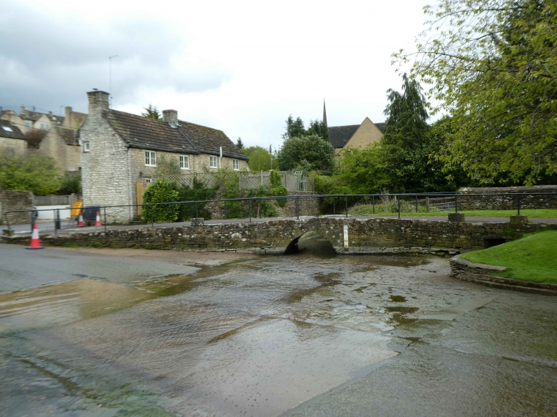
ST 8892-8992 TETBURY CUTWELL
(north end)
8/210 Cutwell Bridge
II
Former packhorse and foot bridge over Avon tributary on road into
Tetbury from south west. c1622. Single triangular arch about lm
high and 2m wide at base with large voussoirs. Bridge platform
about 3m wide with long ramp about 25m total length, with C20 iron
railings on both sides, retaining some original slabs but largely
of tarmac. Additional small square tunnel to right with single
stone lintel, for overflow.
Listing NGR: ST8873192994
External links are from the relevant listing authority and, where applicable, Wikidata. Wikidata IDs may be related buildings as well as this specific building. If you want to add or update a link, you will need to do so by editing the Wikidata entry.


Other nearby listed buildings
