Approximate Location Map
Large Map »
Latitude: 51.6346 / 51°38'4"N
Longitude: -2.1613 / 2°9'40"W
OS Eastings: 388935
OS Northings: 192876
OS Grid: ST889928
Mapcode National: GBR 1P0.DDJ
Mapcode Global: VH95K.H59R
Plus Code: 9C3VJRMQ+RF
Entry Name: Bath Bridge
Listing Date: 21 March 1985
Grade: II
Source: Historic England
Source ID: 1089689
English Heritage Legacy ID: 128388
ID on this website: 101089689
Location: Tetbury, Cotswold, Gloucestershire, GL8
County: Gloucestershire
District: Cotswold
Civil Parish: Tetbury
Built-Up Area: Tetbury
Traditional County: Gloucestershire
Lieutenancy Area (Ceremonial County): Gloucestershire
Church of England Parish: Tetbury St Mary the Virgin
Church of England Diocese: Gloucester
Tagged with: Bridge
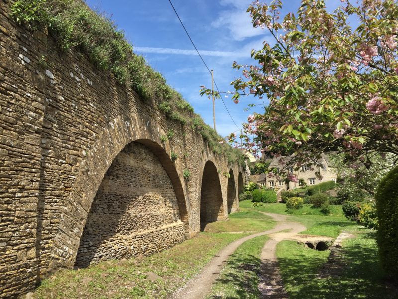
ST 8892-8992 TETBURY BATH ROAD
8/112 Bath Bridge
II
Road bridge carrying A433 (Bath Road) over valley to south of town.
1774-6 by Thomas Webb. Coursed rubble stone with shallow voussoir
arches. 4 arches, lowest (to south) blocked. Bridge slopes up the
hill into town so all arches are of different size.
Listing NGR: ST8893592876
External links are from the relevant listing authority and, where applicable, Wikidata. Wikidata IDs may be related buildings as well as this specific building. If you want to add or update a link, you will need to do so by editing the Wikidata entry.


Other nearby listed buildings
