Approximate Location Map
Large Map »
Latitude: 51.6382 / 51°38'17"N
Longitude: -2.1576 / 2°9'27"W
OS Eastings: 389188
OS Northings: 193273
OS Grid: ST891932
Mapcode National: GBR 1P0.7B5
Mapcode Global: VH95K.K360
Plus Code: 9C3VJRQR+7X
Entry Name: 29 and 31, the Chipping
Listing Date: 6 September 1954
Grade: II
Source: Historic England
Source ID: 1089649
English Heritage Legacy ID: 128398
ID on this website: 101089649
Location: Tetbury, Cotswold, Gloucestershire, GL8
County: Gloucestershire
District: Cotswold
Civil Parish: Tetbury
Built-Up Area: Tetbury
Traditional County: Gloucestershire
Lieutenancy Area (Ceremonial County): Gloucestershire
Church of England Parish: Tetbury St Mary the Virgin
Church of England Diocese: Gloucester
Tagged with: Building
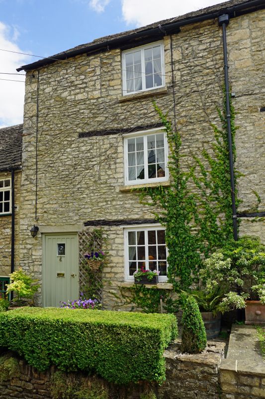
ST 8893-8993 TETBURY THE CHIPPING
(east side)
7/122 Nos 29 and 31
6.9.54
GV II
Pair of cottages in terrace. Early C18. Painted rubble stone,
Cotswold stone slate roof, no chimneys visible. 3 storeys. 2
windows, one to each cottage on each floor, paired casements under
wood lintels. No 29 has door on right, with 4 flush panels. No
31 has door on left, C20 boarded.
Listing NGR: ST8919193270
External links are from the relevant listing authority and, where applicable, Wikidata. Wikidata IDs may be related buildings as well as this specific building. If you want to add or update a link, you will need to do so by editing the Wikidata entry.


Other nearby listed buildings
