Approximate Location Map
Large Map »
Latitude: 51.6381 / 51°38'17"N
Longitude: -2.1577 / 2°9'27"W
OS Eastings: 389183
OS Northings: 193263
OS Grid: ST891932
Mapcode National: GBR 1P0.7B6
Mapcode Global: VH95K.K352
Plus Code: 9C3VJRQR+6W
Entry Name: 25, the Chipping
Listing Date: 6 September 1954
Last Amended: 21 March 1985
Grade: II
Source: Historic England
Source ID: 1089692
English Heritage Legacy ID: 128397
ID on this website: 101089692
Location: Tetbury, Cotswold, Gloucestershire, GL8
County: Gloucestershire
District: Cotswold
Civil Parish: Tetbury
Built-Up Area: Tetbury
Traditional County: Gloucestershire
Lieutenancy Area (Ceremonial County): Gloucestershire
Church of England Parish: Tetbury St Mary the Virgin
Church of England Diocese: Gloucester
Tagged with: Building
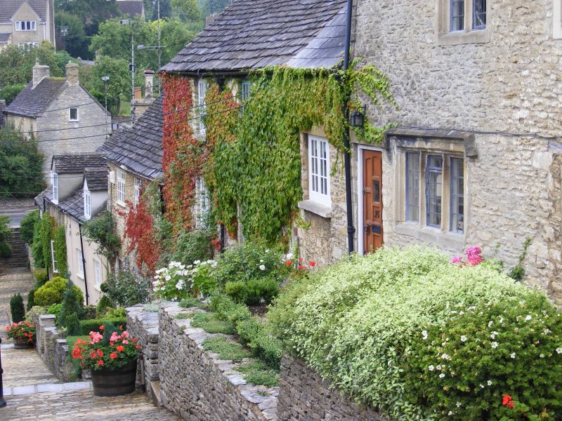
ST 8893-8993 TETBURY THE CHIPPING
(east side)
7/121 No 25
6.9.54 (formerly listed as Nos 25
and 27)
GV II
Formerly 2 cottages, now one house in terrace. Late C17. Rubble
stone with slate roof and one small brick stack to left. 2
storeys and attic, with single storey section to left. One 2-light
stone mullion window with square hoodmould on 1st floor, and 3-
light on ground floor. Original door to No 25 on right has been
blocked and a C17 stone frame inserted with single fixed leaded
light and wooden lintel. Former door to No 27 now C20 half-glazed
with concrete lintel and to left a 3-light wooden casement with
concrete lintel. Gabled dormer with twin casement.
Listing NGR: ST8918593265
External links are from the relevant listing authority and, where applicable, Wikidata. Wikidata IDs may be related buildings as well as this specific building. If you want to add or update a link, you will need to do so by editing the Wikidata entry.


Other nearby listed buildings
