Approximate Location Map
Large Map »
Latitude: 51.7449 / 51°44'41"N
Longitude: -2.2118 / 2°12'42"W
OS Eastings: 385476
OS Northings: 205151
OS Grid: SO854051
Mapcode National: GBR 1MK.KMM
Mapcode Global: VH94Y.MD3Q
Plus Code: 9C3VPQVQ+W7
Entry Name: 42, Acre Street
Listing Date: 25 June 1974
Grade: II
Source: Historic England
Source ID: 1090130
English Heritage Legacy ID: 131295
ID on this website: 101090130
Location: Stroud Hill, Stroud, Gloucestershire, GL5
County: Gloucestershire
District: Stroud
Civil Parish: Stroud
Built-Up Area: Stroud
Traditional County: Gloucestershire
Lieutenancy Area (Ceremonial County): Gloucestershire
Church of England Parish: Stroud St Laurence
Church of England Diocese: Gloucester
Tagged with: Building
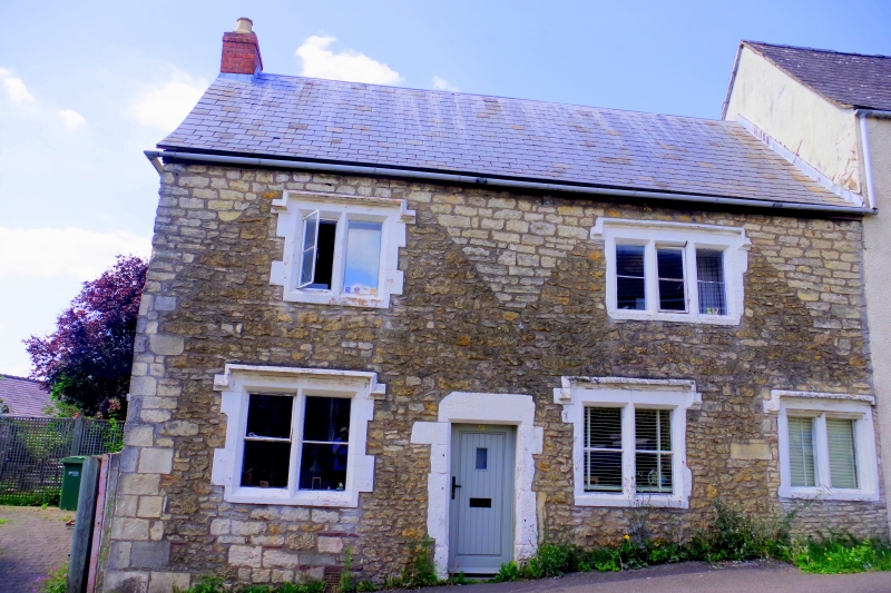
1. ACRE STREET
5227
(West Side)
No 42
SO 8505 5/104
II
2.
C17 Coursed rubble. Ashlar dressings. Pitched slate roof. 2 storeys. 2 ranges
of mullioned casements with hoodmoulds (3 on ground floor).Mid C19 6 panelled C19 6-panelled
door.
Listing NGR: SO8547605151
External links are from the relevant listing authority and, where applicable, Wikidata. Wikidata IDs may be related buildings as well as this specific building. If you want to add or update a link, you will need to do so by editing the Wikidata entry.


Other nearby listed buildings
