Approximate Location Map
Large Map »
Latitude: 51.7447 / 51°44'41"N
Longitude: -2.2122 / 2°12'43"W
OS Eastings: 385448
OS Northings: 205137
OS Grid: SO854051
Mapcode National: GBR 1MK.KJC
Mapcode Global: VH94Y.LDWT
Plus Code: 9C3VPQVQ+V4
Entry Name: Salvation Army Chapel
Listing Date: 17 May 1996
Grade: II
Source: Historic England
Source ID: 1268473
English Heritage Legacy ID: 461786
ID on this website: 101268473
Location: Stroud Hill, Stroud, Gloucestershire, GL5
County: Gloucestershire
District: Stroud
Civil Parish: Stroud
Built-Up Area: Stroud
Traditional County: Gloucestershire
Lieutenancy Area (Ceremonial County): Gloucestershire
Church of England Parish: Stroud St Laurence
Church of England Diocese: Gloucester
Tagged with: Chapel
S85805 STROUD ACRE STREET
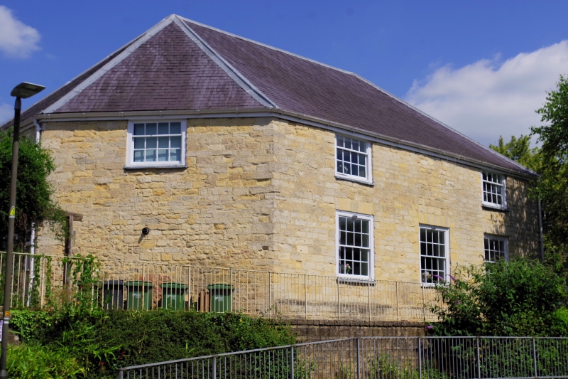
822/5/10015 Salvation Army Chapel
II
Methodist chapel, now used by Salvation Army. 1763, extended 1796; restored 1980s. Coursed and squared stone with hipped slate roof. The regular octagon plan of 1763 was extended in 1796 by doubling the length of the sides and rebuilding the NW end. 2-storey external elevations with 1980s glazing bar sashes and bracketed timber hood over double doors with overlight; the NW end has full-height blocked semi-circular arched windows set over late C20 windows. Interior has early C19 gallery with panelled front set on cast-iron columns; roof rebuilt after fire damage in 1929. This is the oldest surviving example of an octagonal plan Methodist chapel. Octagons, which were favoured as a plan form by John Wesley , represented the most extreme manifestation of the importance of the sermon and the centrality of the word in the Methodist tradition: Wesley himself preached here in 1765, the extension of 1796 not only retains the octagon in elongated form but also represents an early surviving example of an extension dating from a major period of Methodist expansion.
Listing NGR: SO8544805137
External links are from the relevant listing authority and, where applicable, Wikidata. Wikidata IDs may be related buildings as well as this specific building. If you want to add or update a link, you will need to do so by editing the Wikidata entry.


Other nearby listed buildings
