Latitude: 50.9884 / 50°59'18"N
Longitude: -1.4997 / 1°29'59"W
OS Eastings: 435208
OS Northings: 121117
OS Grid: SU352211
Mapcode National: GBR 757.ZM3
Mapcode Global: FRA 76RH.MJN
Plus Code: 9C2WXGQ2+94
Entry Name: Cross Keys Public House
Listing Date: 4 December 1972
Grade: II
Source: Historic England
Source ID: 1092660
English Heritage Legacy ID: 139449
ID on this website: 101092660
Location: Romsey, Test Valley, Hampshire, SO51
County: Hampshire
District: Test Valley
Civil Parish: Romsey
Built-Up Area: Romsey
Traditional County: Hampshire
Lieutenancy Area (Ceremonial County): Hampshire
Church of England Parish: Romsey St Mary and St Ethelflaeda
Church of England Diocese: Winchester
Tagged with: Pub
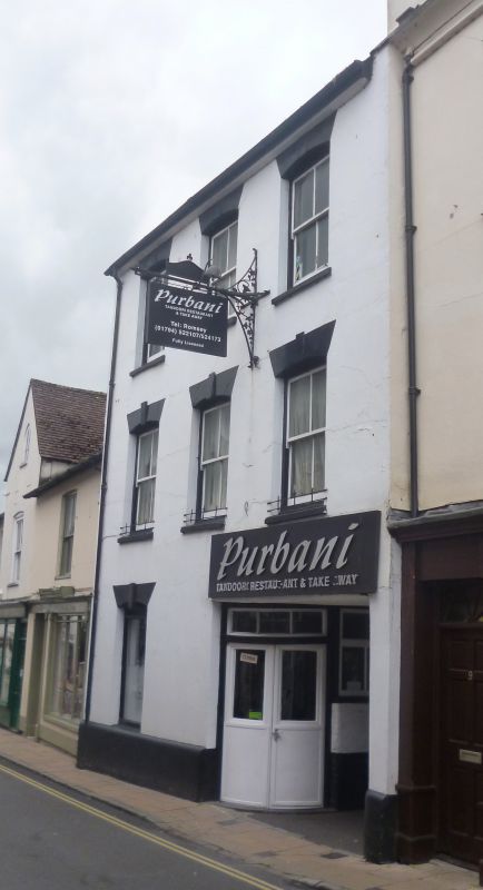
BELL STREET 1. (West Side) 1559 ----------- No 11 (Cross Keys Public House) SU 3521 4/136
II GV
2. 2 parallel ranges. Carriageway through both ranges at north end. Back range smaller; C17 or earlier and timber-framed with timber-framed wing extending westwards along yard. Front range early to mid C19. 3-storeys. Painted stucco. 3 bays. Sash windows without glazing bars in reveals in slightly segmental arches; stuccoed voussoirs with central keystones. On ground floor one similar window to south. Doorway on corner of building, south of carriageway, with pair of bow-fronted doors following curve of building; each door with one flush panel below and glazing above; curved rectangular fanlight of 3 lights, In east-west timber-framed wing running along yard behind, square panels of timber-framing with some diagonal braces. 3 bays. 2-light casement windows above; 2 large sash windows below and 2 doorways. Right hand doorway has door with flush panels in reveals behind architrave frame with flat hood on brackets over. Left hand doorway has door with 4 fielded panels in reveals behind doorway with avchitrave frame. Tall single storey C19 extension to south-west of tis. Painted brick. 2 round headed windows and one doorway.
Nos 3 to 15 (odd) form a group.
Listing NGR: SU3520621115
External links are from the relevant listing authority and, where applicable, Wikidata. Wikidata IDs may be related buildings as well as this specific building. If you want to add or update a link, you will need to do so by editing the Wikidata entry.


Other nearby listed buildings