Approximate Location Map
Large Map »
Latitude: 51.1685 / 51°10'6"N
Longitude: -1.3508 / 1°21'2"W
OS Eastings: 445485
OS Northings: 141228
OS Grid: SU454412
Mapcode National: GBR 84N.MBD
Mapcode Global: VHD0H.JWRM
Plus Code: 9C3W5J9X+9M
Entry Name: Church of St Michael
Listing Date: 20 December 1960
Grade: II*
Source: Historic England
Source ID: 1093440
English Heritage Legacy ID: 139571
ID on this website: 101093440
Location: St Michael's Church, Lower Bullington, Test Valley, Hampshire, SO21
County: Hampshire
District: Test Valley
Civil Parish: Bullington
Traditional County: Hampshire
Lieutenancy Area (Ceremonial County): Hampshire
Church of England Parish: Barton Stacey All Saints
Church of England Diocese: Winchester
Tagged with: Church building
5240
SU 44 SE BULLINGTON LOWER BULLINGTON
20-12-60
5/7
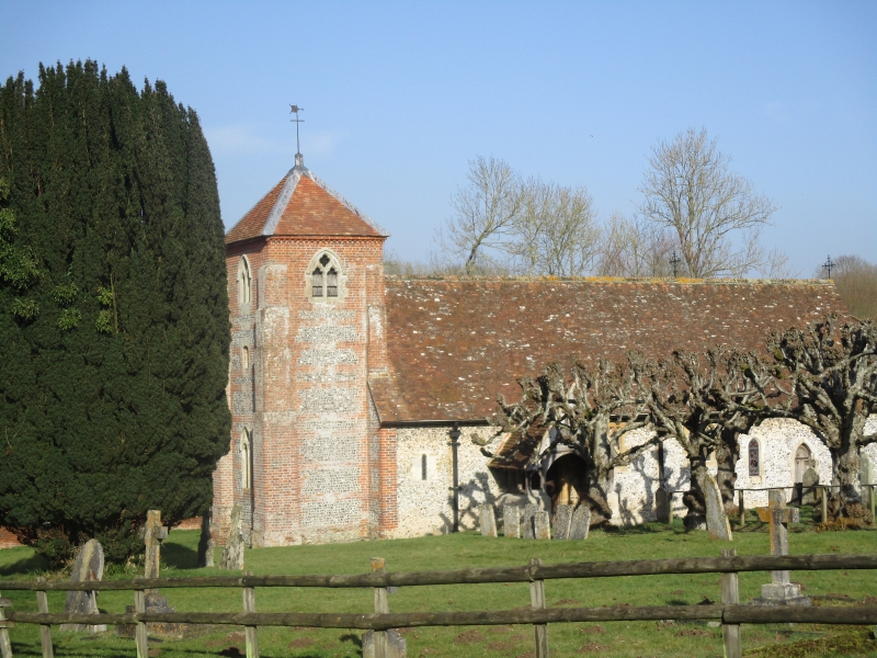
Church of St. Michael
II*
Parish church. Late C12, early C13, early C19, and restoration of 1871.
Single cell, of Norman nave and a chancel of circa 1220, with a western tower
of the third period; a north vestry, south porch, and some restoration details
are of 1871. Flint walls with stone-dressings; 2 small Norman windows at the
west end of the nave, a lancet on the southside of the chancel and a Norman
doorway (blocked) on the north side; the restoration work includes triple lancets
at the east end, 2 small 'Perpendicular' windows at the south side of the nave,
a priest's door, and windows and door of the vestry. The tower is of red
brickwork with flint panels, corner flat buttresses, the top of the brickwork
finishing as a dentil eaves to the pyramid roof; small 'Geometrical' belfry
windows, and a larger west window. Single tiled roof, extending over the
outshots (vestry and heating chamber) on the north side. The south porch has a
tile and gabled roof above an open timber framework, resting on a base wall.
Inside, the details are all of the last period, but there are 4 wall monuments
of the period 1800 to 1830, and a floorslab of 1727: the tower arch is a plan
semi-circle above impost bands.
Listing NGR: SP3767439287
External links are from the relevant listing authority and, where applicable, Wikidata. Wikidata IDs may be related buildings as well as this specific building. If you want to add or update a link, you will need to do so by editing the Wikidata entry.


Other nearby listed buildings
