Latitude: 51.2109 / 51°12'39"N
Longitude: -1.477 / 1°28'37"W
OS Eastings: 436630
OS Northings: 145871
OS Grid: SU366458
Mapcode National: GBR 72R.5D5
Mapcode Global: VHC2S.CT1M
Plus Code: 9C3W6G6F+96
Entry Name: 15 and 17, Church Close
Listing Date: 24 June 1983
Grade: II
Source: Historic England
Source ID: 1093492
English Heritage Legacy ID: 139484
ID on this website: 101093492
Location: Andover, Test Valley, Hampshire, SP10
County: Hampshire
District: Test Valley
Civil Parish: Andover
Built-Up Area: Andover
Traditional County: Hampshire
Lieutenancy Area (Ceremonial County): Hampshire
Church of England Parish: Andover St Mary
Church of England Diocese: Winchester
Tagged with: Building
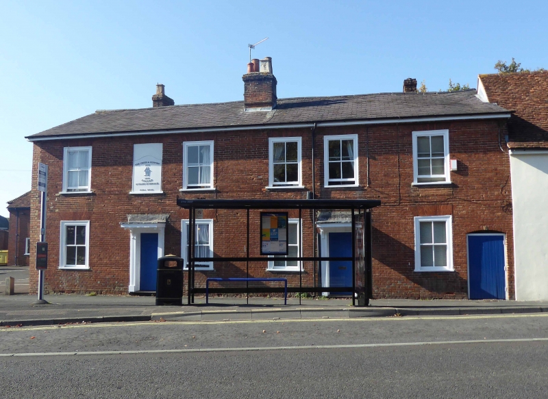
SU 3645 NE ANDOVER CHURCH CLOSE FORMERLY
4/26 NEW STREET
Nos 15 and 17
II
Early C19. Symmetrical pair of 2 storeys, 3.3 windows. Slate roof. Red brick
walling in Flemish bond, rubbers. Victorian sashes in exposed frames. Doorcases have
canopies on brackets, 6-flush-panelled doors, a further door at the north side is
boarded, within a solid frame.
Listing NGR: SU3659445758
External links are from the relevant listing authority and, where applicable, Wikidata. Wikidata IDs may be related buildings as well as this specific building. If you want to add or update a link, you will need to do so by editing the Wikidata entry.


Other nearby listed buildings