Latitude: 51.3891 / 51°23'20"N
Longitude: 1.3819 / 1°22'54"E
OS Eastings: 635390
OS Northings: 170992
OS Grid: TR353709
Mapcode National: GBR WZS.VLH
Mapcode Global: VHLG6.WBXY
Plus Code: 9F3399QJ+JQ
Entry Name: 16, Market Place
Listing Date: 22 February 1973
Grade: II
Source: Historic England
Source ID: 1094657
English Heritage Legacy ID: 356627
ID on this website: 101094657
Location: Margate, Thanet, Kent, CT9
County: Kent
District: Thanet
Electoral Ward/Division: Margate Central
Parish: Non Civil Parish
Built-Up Area: Margate
Traditional County: Kent
Lieutenancy Area (Ceremonial County): Kent
Tagged with: Building
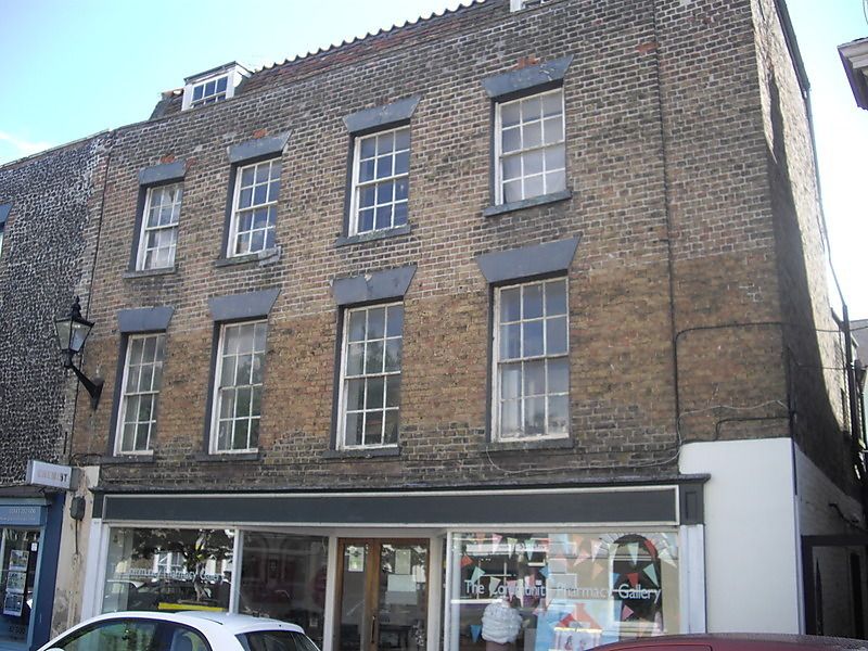
MARKET PLACE
1.
1380 (South Side)
No 16
TR 3570 NW 1/248
II GV
2.
Late C18. 3 storeys and attics stock brick. Partly pantiled; partly tiled
mansard roof with 2 dormers. Stone coping. 4 sashes with glazing bars intact.
Stone heads and cills. Lampholder. Early C19 shopfront.
Nos 13 to 20 (consec) and No 1 Market Street form a group
Listing NGR: TR3539070992
External links are from the relevant listing authority and, where applicable, Wikidata. Wikidata IDs may be related buildings as well as this specific building. If you want to add or update a link, you will need to do so by editing the Wikidata entry.


Other nearby listed buildings