Approximate Location Map
Large Map »
Latitude: 52.8253 / 52°49'30"N
Longitude: -1.4258 / 1°25'33"W
OS Eastings: 438784
OS Northings: 325459
OS Grid: SK387254
Mapcode National: GBR 6G3.SD3
Mapcode Global: WHDHF.279X
Plus Code: 9C4WRHGF+4M
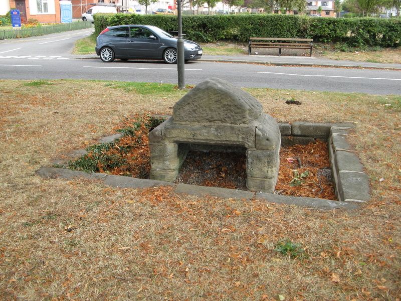
Entry Name: Well Head at SK 3878 2546
Listing Date: 11 March 1987
Grade: II
Source: Historic England
Source ID: 1096369
English Heritage Legacy ID: 83152
ID on this website: 101096369
Location: Lilypool, South Derbyshire, DE73
County: Derbyshire
District: South Derbyshire
Civil Parish: Melbourne
Built-Up Area: Melbourne
Traditional County: Derbyshire
Lieutenancy Area (Ceremonial County): Derbyshire
Church of England Parish: Melbourne St Michael
Church of England Diocese: Derby
Tagged with: Well
SK 38/3925 PARISH OF MELBOURNE STATION ROAD
6/168 (South Side)
Well Head at
SK 3878 2546
II
Well head. C17 with C20 restoration. Stone. Sunken well head
with short walls on three sides, capped by a large triangular
shaped coping stone which forms a roof. South side is open and
has moulded edges, also a stone trough to base.
Listing NGR: SK3878425459
External links are from the relevant listing authority and, where applicable, Wikidata. Wikidata IDs may be related buildings as well as this specific building. If you want to add or update a link, you will need to do so by editing the Wikidata entry.


Other nearby listed buildings
