Latitude: 52.2416 / 52°14'29"N
Longitude: 0.7135 / 0°42'48"E
OS Eastings: 585363
OS Northings: 263846
OS Grid: TL853638
Mapcode National: GBR QF0.F6V
Mapcode Global: VHKD4.BX1H
Plus Code: 9F426PR7+JC
Entry Name: 38, Whiting Street
Listing Date: 12 July 1972
Last Amended: 30 October 1997
Grade: II
Source: Historic England
Source ID: 1096766
English Heritage Legacy ID: 467777
ID on this website: 101096766
Location: Bury St Edmunds, West Suffolk, IP33
County: Suffolk
District: West Suffolk
Civil Parish: Bury St Edmunds
Built-Up Area: Bury St Edmunds
Traditional County: Suffolk
Lieutenancy Area (Ceremonial County): Suffolk
Church of England Parish: Bury St Edmunds St Mary
Church of England Diocese: St.Edmundsbury and Ipswich
Tagged with: Building
BURY ST EDMUNDS
TL8563NW WHITING STREET 639-1/15/706 (East side) 12/07/72 No.38 (Formerly Listed as: WHITING STREET (East side) Nos.36 AND 38)
GV II
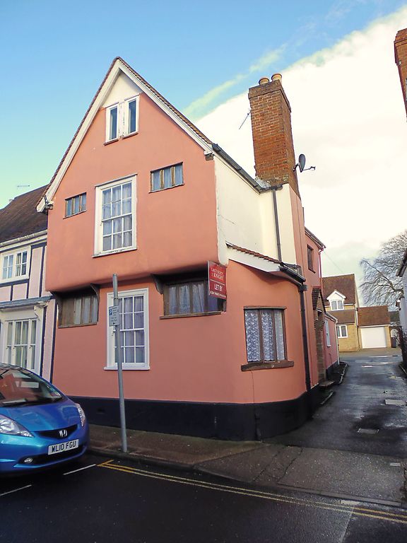
House, formerly the cross-wing to No.36 (qv), now a separate dwelling. Late C15/early C16 and later. Timber-framed and rendered; plaintiled roof. EXTERIOR: 2 storeys and attic; jettied along the street frontage. A 12-pane sash window in a flush cased frame to the ground and 1st storeys, flanked on each side by original high windows with moulded mullions, 3-light on the 1st storey and 4-light on the ground storey. 2 linked C20 single-light windows in the apex of the gable. The jetty is supported on shaped brackets. A rounded single storey corner extension with a C20 3-light window and sloping plaintiled roof is linked to a side chimney-stack with a plain red brick shaft. The C20 entrance is along the side wall. INTERIOR: small cellar, not inspected. Frame in two 2-bay sections, the rear a later addition. The 2-bay front room has a heavy main beam with large chamfer and the remains of a timber fireplace lintel. In the front upper room the main beam has been replaced and the long arched braces removed. The roof above has a collar-purlin supported by thin braces. Little framing exposed in the rear of the building.
Listing NGR: TL8536363846
External links are from the relevant listing authority and, where applicable, Wikidata. Wikidata IDs may be related buildings as well as this specific building. If you want to add or update a link, you will need to do so by editing the Wikidata entry.


Other nearby listed buildings