Approximate Location Map
Large Map »
Latitude: 51.2766 / 51°16'35"N
Longitude: 1.0788 / 1°4'43"E
OS Eastings: 614832
OS Northings: 157549
OS Grid: TR148575
Mapcode National: GBR TY2.X5W
Mapcode Global: VHLGM.N55Q
Plus Code: 9F3373GH+JG
Entry Name: 2, Marlowe Avenue
Listing Date: 7 September 1973
Grade: II
Source: Historic England
Source ID: 1097027
English Heritage Legacy ID: 439705
ID on this website: 101097027
Location: Canterbury, Kent, CT1
County: Kent
District: Canterbury
Electoral Ward/Division: Westgate
Parish: Non Civil Parish
Built-Up Area: Canterbury
Traditional County: Kent
Lieutenancy Area (Ceremonial County): Kent
Tagged with: Building
1.
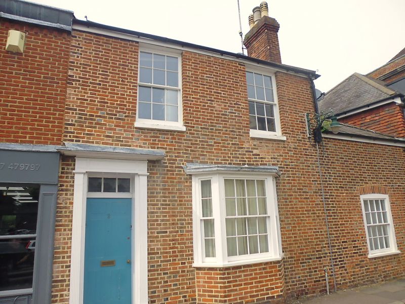
944 MARLOWE AVENUE
No 2
TR 1457 NE 4/560
II
2.
early C19. 2 storeys and basement red brick. Slate roof. 2 sashes with glazing
bars intact and stone cills. 1 3 light canted bay on ground floor with some
glazing bars missing. Left side doorcase has vestigial hood and reeded pilasters,
rectangular fanlight and 6 flush panelled door. Footscraper.
Listing NGR: TR1482957549
External links are from the relevant listing authority and, where applicable, Wikidata. Wikidata IDs may be related buildings as well as this specific building. If you want to add or update a link, you will need to do so by editing the Wikidata entry.


Other nearby listed buildings
