Approximate Location Map
Large Map »
Latitude: 50.5588 / 50°33'31"N
Longitude: -3.533 / 3°31'58"W
OS Eastings: 291510
OS Northings: 74346
OS Grid: SX915743
Mapcode National: GBR P1.1Z83
Mapcode Global: FRA 37HL.7FX
Plus Code: 9C2RHF58+GR
Entry Name: Ruins of Bishop's Palace at Ash Hill Farm
Listing Date: 23 August 1955
Grade: II*
Source: Historic England
Source ID: 1097789
English Heritage Legacy ID: 85677
Also known as: Bishop's Palace
ID on this website: 101097789
Location: Bishopsteignton, Teignbridge, Devon, TQ14
County: Devon
District: Teignbridge
Civil Parish: Bishopsteignton
Traditional County: Devon
Lieutenancy Area (Ceremonial County): Devon
Church of England Parish: Bishopsteignton St John the Baptist
Church of England Diocese: Exeter
Tagged with: Episcopal palace
BISHOPSTEIGNTON
SX 07 SW
10/14 Ruins of Bishop's Palace at Ash
Hill Farm
23.8.55
II*
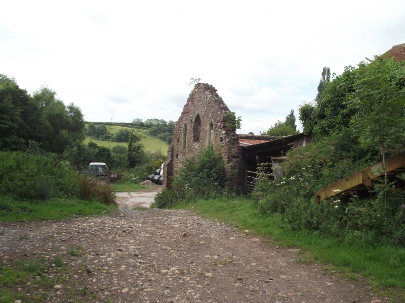
Parts of curtain walls and remains of chapel. Probably early C14. Red sandstone and
brecchia rubble, neatly dressed with some evidence of render on the curtain walling ;
chapel dressings a yellowish stone, possibly Salcombe Regis. The site is described
in detail by Michael Laithwaite in a Devon County Council Archaeological Report.
Plan: A stretch of tall wall to the east of the site and a second section
approximately 100 metres to the west appear to indicate the width of the enclosing
walls of the site ; a recently exposed lower section of wall to the north may be the
remains of the north enclosing wall. The chapel remains consist of a tall south wall
and east wall with cusped lancet windows. There are several farmbuildings on the
site and the west curtain wall is within a cattle shed. Although the site has been
extensively robbed for building material the surviving remains above ground are of
major interest and features, including a flight of stone steps, are known to survive
below ground (information from Mr Dawe, the owner).
The east curtain wall, about 50 metres long with some putlog holes, retains some
coping. At the south end it returns with an external coped buttress. The west wall,
about 40 metres long, also retains some coping and seems to have been broken through
at the south end to form an entrance to the farmyard. The chapel south wall retains
5 trefoil-headed lancet windows to the nave, deeply-splayed to the interior, and the
remains of buttressing, 2 adjacent openings on the south side to the west, one
probably an original doorway. The south side of the chancel has an opening, set
surprisingly high in the wall for a doorway, and the remains of a lancet window, only
the jambs and sill surviving. The east wall has a trefoil-headed lancet to the
south, similar window to the north largely obscured by ivy and a ruinous window in
the centre. A cusped holy water stoup survives on the south wall inside the former
chapel.
Bishop John de Grandisson (1327-69) refers to the buildings in his will (Laithwaite).
Laithwaite, M., Devon County Council Archaeological Report (1987).
Listing NGR: SX9151074346
External links are from the relevant listing authority and, where applicable, Wikidata. Wikidata IDs may be related buildings as well as this specific building. If you want to add or update a link, you will need to do so by editing the Wikidata entry.


Other nearby listed buildings
