Approximate Location Map
Large Map »
Latitude: 50.6929 / 50°41'34"N
Longitude: -3.251 / 3°15'3"W
OS Eastings: 311732
OS Northings: 88888
OS Grid: SY117888
Mapcode National: GBR P8.9X8S
Mapcode Global: FRA 4727.WSN
Plus Code: 9C2RMPVX+5H
Entry Name: Barn Approximately 60 Feet South West of Bulverton Well Farmhouse
Listing Date: 12 November 1973
Grade: II
Source: Historic England
Source ID: 1097973
English Heritage Legacy ID: 87223
ID on this website: 101097973
Location: Bulverton, East Devon, EX10
County: Devon
District: East Devon
Civil Parish: Sidmouth
Built-Up Area: Sidmouth
Traditional County: Devon
Lieutenancy Area (Ceremonial County): Devon
Church of England Parish: Woolbrook St Francis of Assisi
Church of England Diocese: Exeter
Tagged with: Barn Thatched barn
BULVERTON ROAD
1.
1633
Barn approximately
60 ft south west
of Bulverton Well
Farmhouse.
SY 18 NV 14/150
II
2.
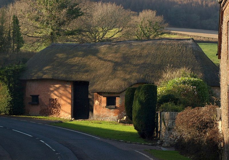
Old cob building set at angle to road. Well repaired with brickwork.
Semi-circular projection on road front. Thatched roof with undulating
eaves line. Hatches and large double stable doors. Raised doorway with
curved flight of stone steps. Part of a small rural development just
north of Sidmouth proper, near junction of Bulverton Road with Dark Lane.
Listing NGR: SY1173288888
External links are from the relevant listing authority and, where applicable, Wikidata. Wikidata IDs may be related buildings as well as this specific building. If you want to add or update a link, you will need to do so by editing the Wikidata entry.


Other nearby listed buildings
