Approximate Location Map
Large Map »
Latitude: 54.2013 / 54°12'4"N
Longitude: -2.9543 / 2°57'15"W
OS Eastings: 337846
OS Northings: 478811
OS Grid: SD378788
Mapcode National: GBR 7MTV.6Q
Mapcode Global: WH83C.LNFL
Plus Code: 9C6V622W+G7
Entry Name: Cavendish Arms Public House with Attached Outbuilding
Listing Date: 25 March 1970
Grade: II
Source: Historic England
Source ID: 1099113
English Heritage Legacy ID: 76973
ID on this website: 101099113
Location: Cartmel, Westmorland and Furness, Cumbria, LA11
County: Cumbria
District: South Lakeland
Civil Parish: Lower Allithwaite
Traditional County: Lancashire
Lieutenancy Area (Ceremonial County): Cumbria
Church of England Parish: Cartmel St Mary and St Michael
Church of England Diocese: Carlisle
Tagged with: Pub
LOWER ALLITHWAITE CAVENDISH STREET
SD 3778
(East side) Cartmel
8/60 Cavendish Arms Public
25.3.70 House with attached
outbuilding
G.V. II
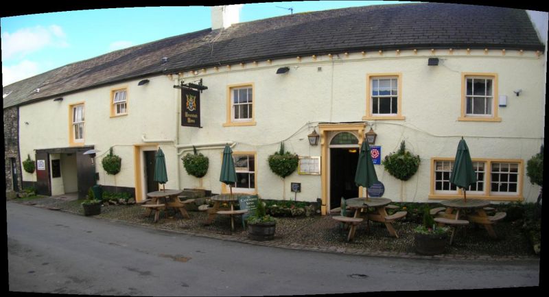
Public House. Probably C18 with later additions. Roughcast stone with slate
roof. 2 storeys, 5 bays, the end 2 bays project and are higher. 1st 3 bays
have frieze and bracketed eaves. Windows are sashed, most with vertical glazing
bars; triple window to 3rd bay of ground floor has sashes with glazing bars.
4th and 5th bays have windows with small-paned fixed glazing with opening
lights; large entrance between has loading doors above; plate glass window to
return. 1st floor has sashed windows, with glazing bars to 4th bay.
Segmental-headed entrance has panelled pilasters, consoled flat canopy and
6-panel door; fanlight with spandrel fan motifs. Double-sided mounting block
has panel with date: 1837. Outbuilding to left has large sliding doors entrance
and loading door. Further outbuilding to left has large and small entrances.
Cross-axial stack and gable-end stacks. Rear has low gabled wings and
flat-roofed extension. Interior has some stop-chamfered beams.
Listing NGR: SD3785678829
External links are from the relevant listing authority and, where applicable, Wikidata. Wikidata IDs may be related buildings as well as this specific building. If you want to add or update a link, you will need to do so by editing the Wikidata entry.


Other nearby listed buildings
