Latitude: 51.808 / 51°48'28"N
Longitude: -0.3464 / 0°20'47"W
OS Eastings: 514100
OS Northings: 213442
OS Grid: TL141134
Mapcode National: GBR H7J.P6Q
Mapcode Global: VHFRV.YT7C
Plus Code: 9C3XRM53+5C
Entry Name: Railway Bridge over Southdown Road
Listing Date: 27 September 1984
Grade: II
Source: Historic England
Source ID: 1103004
English Heritage Legacy ID: 163612
ID on this website: 101103004
Location: Hatching Green, St. Albans, Hertfordshire, AL5
County: Hertfordshire
District: St. Albans
Civil Parish: Harpenden
Built-Up Area: Harpenden
Traditional County: Hertfordshire
Lieutenancy Area (Ceremonial County): Hertfordshire
Church of England Parish: Harpenden St John
Church of England Diocese: St.Albans
Tagged with: Arch bridge Railway bridge
TL 11 SW HARPENDEN SOUTHDOWN ROAD HARPENDEN
5/78 Railway bridge over Southdown Road
II
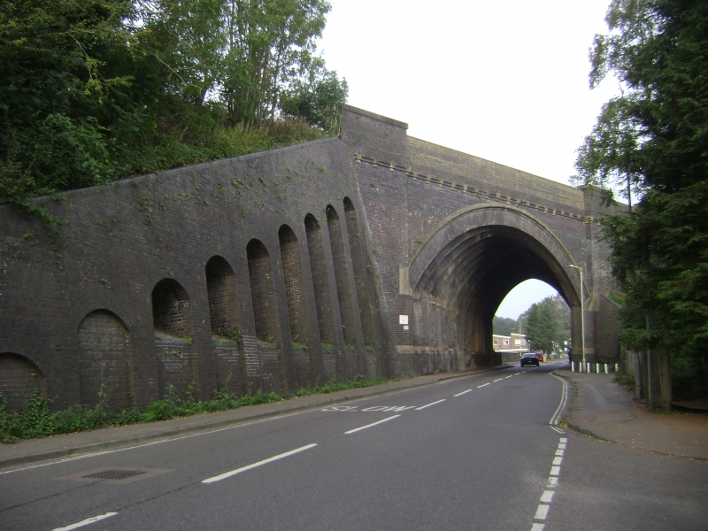
Railway bridge. Circa 1865 by Liddell and Barlow. Extended on W side circa 1880, when the London-Midland track was made quadruple. Cambridge blue brick. The E side has stone dressings. The W side is mostly in dark red stock brick. Semicircular tunnel arch crossing the road at a steep angle, giving the arch the appearance of a parabola. The elevations have 1 and 2 broad plain piers, left and right of the arch. Deep parapet. The E side has a stone roll moulding round the arch and T-shaped stone modillions in the stepped brick band below the parapet. On the E side the blue and stock bricks are indiscriminately mixed and the piers of the parapet have brick modillions. The tunnel arch comprises 18 square sections set diagonally and overlapping each other in a criss-cross, stepped formation. The 9 sections on the E side have smooth stone imposts. Continuous plain plinth, capped in stone on the E half. On the NE and SW embankments are sloping abutments in blue brick. Each has deep rectangular buttresses linked by deep arched recesses which terminate as niches. Long sloping elevations finished by short brick piers.
Listing NGR: TL1410013442
External links are from the relevant listing authority and, where applicable, Wikidata. Wikidata IDs may be related buildings as well as this specific building. If you want to add or update a link, you will need to do so by editing the Wikidata entry.


Other nearby listed buildings