Latitude: 51.7502 / 51°45'0"N
Longitude: -0.3399 / 0°20'23"W
OS Eastings: 514695
OS Northings: 207026
OS Grid: TL146070
Mapcode National: GBR H89.BVH
Mapcode Global: VHGPQ.285M
Plus Code: 9C3XQM26+32
Entry Name: 11, Holywell Hill
Listing Date: 27 August 1971
Grade: II
Source: Historic England
Source ID: 1103092
English Heritage Legacy ID: 163325
ID on this website: 101103092
Location: St Albans, St. Albans, Hertfordshire, AL1
County: Hertfordshire
District: St. Albans
Electoral Ward/Division: St Peters
Parish: Non Civil Parish
Built-Up Area: St Albans
Traditional County: Hertfordshire
Lieutenancy Area (Ceremonial County): Hertfordshire
Church of England Parish: Abbey Parish of St Albans
Church of England Diocese: St.Albans
Tagged with: Building
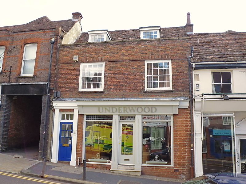
HOLYWELL HILL
1. (East Side)
1582
No 11
TL 1407 SE 9/227
II GV
2.
Earlier C18 front on early C17 house. 2 storeys and attic, 2 windows
High pitched, tiled roof with 2 square headed dormers. Red brick with
parapet. Gauged, brick arches to sash windows with glazing bars on
1st floor, in near-flush moulded frames.
Modern brick on ground floor with bowed shop window.
Gabled, Cl7 extension to rear.
Nos 1 to 25 (odd) form a group.
Listing NGR: TL1469507026
External links are from the relevant listing authority and, where applicable, Wikidata. Wikidata IDs may be related buildings as well as this specific building. If you want to add or update a link, you will need to do so by editing the Wikidata entry.


Other nearby listed buildings