Latitude: 51.7504 / 51°45'1"N
Longitude: -0.3399 / 0°20'23"W
OS Eastings: 514698
OS Northings: 207047
OS Grid: TL146070
Mapcode National: GBR H89.BWJ
Mapcode Global: VHGPQ.285H
Plus Code: 9C3XQM26+53
Entry Name: 5, Holywell Hill
Listing Date: 8 May 1950
Grade: II
Source: Historic England
Source ID: 1103090
English Heritage Legacy ID: 163323
ID on this website: 101103090
Location: St Albans, St. Albans, Hertfordshire, AL1
County: Hertfordshire
District: St. Albans
Electoral Ward/Division: St Peters
Parish: Non Civil Parish
Built-Up Area: St Albans
Traditional County: Hertfordshire
Lieutenancy Area (Ceremonial County): Hertfordshire
Church of England Parish: Abbey Parish of St Albans
Church of England Diocese: St.Albans
Tagged with: Building
HOLYWELL HILL 1. (East Side) 1582 No 5 5
TL 1407 SE 9/101 8.5.50.
II GV
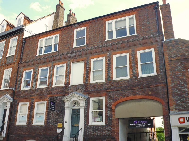
2. Early C18 house of 2 storeys and basement, 7 windows. A 3rd storey added mid C19 with 3 windows, 2-light at sides and one-light in centre. Brick band at 1st floor. Parapet masks high pitched, tiled roof, which can be seen from rear with gabled dormers and deep, moulded eaves cornice. Front of blue brick with red brick dressings (except added, storey of purplish brick). Gauged, flat brick arches to lst floor windows with replaced sashes, in flush, moulded frames. Centre window blocked. 3 similar windows on ground floor. Rendered plinth. 6 stone steps, with cast iron handrails, to door of 6 fielded panels, with cornice head and patterned fanlight; in doorcase with pilasters with fluted necking and cornice and open pediment with modillions and dentils, exactly as No 3. Carriageway on ground floor right.
Nos 1 to 25 (odd) form a group.
Listing NGR: TL1471007046
External links are from the relevant listing authority and, where applicable, Wikidata. Wikidata IDs may be related buildings as well as this specific building. If you want to add or update a link, you will need to do so by editing the Wikidata entry.


Other nearby listed buildings