Approximate Location Map
Large Map »
Latitude: 51.7495 / 51°44'58"N
Longitude: -0.3408 / 0°20'26"W
OS Eastings: 514637
OS Northings: 206944
OS Grid: TL146069
Mapcode National: GBR H89.BN5
Mapcode Global: VHGPQ.19P6
Plus Code: 9C3XPMX5+QM
Entry Name: 44 and 46, Holywell Hill
Listing Date: 27 August 1971
Grade: II
Source: Historic England
Source ID: 1103100
English Heritage Legacy ID: 163340
ID on this website: 101103100
Location: St Albans, St. Albans, Hertfordshire, AL1
County: Hertfordshire
District: St. Albans
Electoral Ward/Division: Verulam
Parish: Non Civil Parish
Built-Up Area: St Albans
Traditional County: Hertfordshire
Lieutenancy Area (Ceremonial County): Hertfordshire
Church of England Parish: Abbey Parish of St Albans
Church of England Diocese: St.Albans
Tagged with: Building
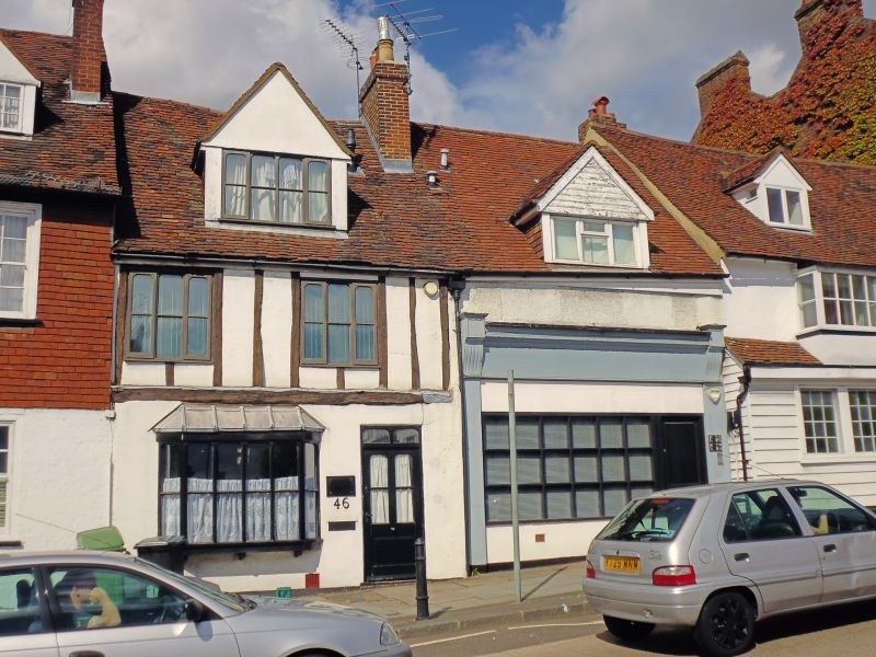
HOLYWELL HILL
1. (West Side)
1582
Nos 44 & 46
TL 1406 NE 14/234
II GV
2.
No 44: C17 house much altered, 2 storeys and attic, 2 windows. Large,
tiled, gabled dormer in renewed, high pitched, tiled roof. First floor
roughcast, old first floor windows blocked and 2 tiny, single lights
Inserted. Ground floor later C19 shop front. No 46: late C16 or Cl7
early house, re-fronted. 2 storeys, 2 windows. Very high pitched, tiled
roof with eaves cornices First floor windows modern sashes with glazing
bars, ground floor modern shop front.
Nos 36 to 58 (even) form a group.
Listing NGR: TL1463706944
External links are from the relevant listing authority and, where applicable, Wikidata. Wikidata IDs may be related buildings as well as this specific building. If you want to add or update a link, you will need to do so by editing the Wikidata entry.


Other nearby listed buildings
