Approximate Location Map
Large Map »
Latitude: 50.8067 / 50°48'24"N
Longitude: -1.0872 / 1°5'13"W
OS Eastings: 464415
OS Northings: 101193
OS Grid: SU644011
Mapcode National: GBR VRN.DK
Mapcode Global: FRA 86MY.SBV
Plus Code: 9C2WRW47+M4
Entry Name: 387 and 389, Old Commercial Road
Listing Date: 25 September 1972
Last Amended: 18 March 1999
Grade: II
Source: Historic England
Source ID: 1103848
English Heritage Legacy ID: 474975
ID on this website: 101103848
Location: Landport, Portsmouth, Hampshire, PO1
County: City of Portsmouth
Electoral Ward/Division: Charles Dickens
Parish: Non Civil Parish
Built-Up Area: Portsmouth
Traditional County: Hampshire
Lieutenancy Area (Ceremonial County): Hampshire
Church of England Parish: Portsea All Saints
Church of England Diocese: Portsmouth
Tagged with: Building
PORTSMOUTH
SU6401 OLD COMMERCIAL ROAD, Landport
774-1/7/278 (West side)
25/09/72 Nos.387 AND 389
(Formerly Listed as:
COMMERCIAL ROAD, Landport
Nos.387 AND 389)
GV II
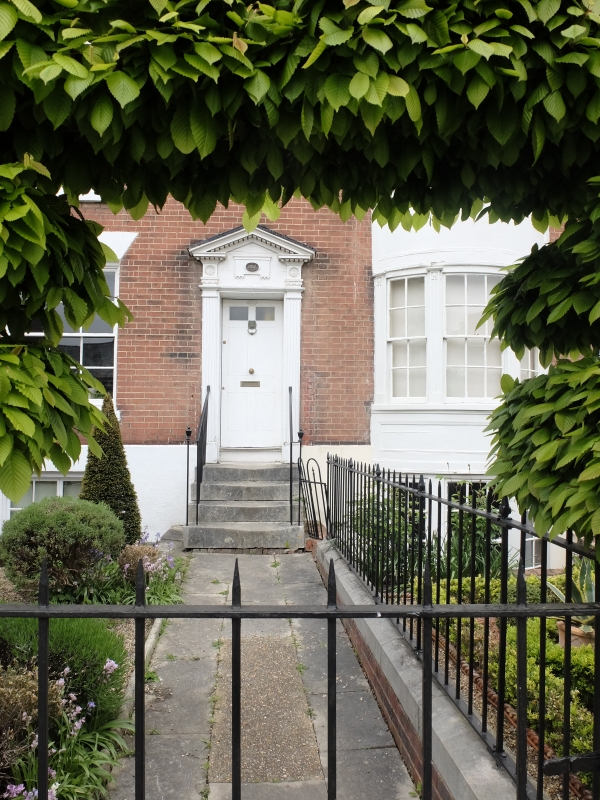
2 houses. c1800. Red brick in Flemish bond. Plain tile hipped
roof, brick stack to left and right. Each has on right flush
panelled door approached by 4 stone steps with attached timber
baluster rails, flanking fluted pilaster door case, moulded
pediment. On left No.387 has 12-pane sash set under gauged
brick flat arch. No.389 has shallow tripartite bow 2 storeys
high, with centre 12-pane sash and 8-pane flanking sashes,
panelled pilasters dividing lights, frieze and cornice. No.387
has 12-pane sash on first and 9-pane unequal sash on second
floor. No.389 has 12-pane first and second floor sash.
INTERIOR not inspected.
Listing NGR: SU6441401191
External links are from the relevant listing authority and, where applicable, Wikidata. Wikidata IDs may be related buildings as well as this specific building. If you want to add or update a link, you will need to do so by editing the Wikidata entry.


Other nearby listed buildings
