Approximate Location Map
Large Map »
Latitude: 50.8037 / 50°48'13"N
Longitude: -1.0768 / 1°4'36"W
OS Eastings: 465147
OS Northings: 100866
OS Grid: SU651008
Mapcode National: GBR VT9.5N
Mapcode Global: FRA 86MZ.49D
Plus Code: 9C2WRW3F+F7
Entry Name: Churchyard Wall and Gate Piers of St Marys Church, Kingston
Listing Date: 25 September 1972
Grade: II
Source: Historic England
Source ID: 1104280
English Heritage Legacy ID: 474596
ID on this website: 101104280
Location: Fratton, Portsmouth, Hampshire, PO1
County: City of Portsmouth
Electoral Ward/Division: Charles Dickens
Parish: Non Civil Parish
Built-Up Area: Portsmouth
Traditional County: Hampshire
Lieutenancy Area (Ceremonial County): Hampshire
Church of England Parish: Portsea St Mary
Church of England Diocese: Portsmouth
Tagged with: Churchyard wall
PORTSMOUTH
SU6500 FRATTON ROAD, Fratton
774-1/10/177 (East side)
25/09/72 Churchyard wall and gate piers of St
Mary's Church, Kingston
GV II
Includes: Churchyard wall and gate piers of St Mary's Church,
Kingston ST MARY'S ROAD Fratton.
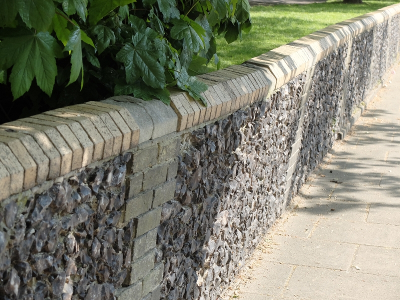
Churchyard walls and gate piers. c1887-89. Knapped flint.
Portland stone and yellow stock bricks. Random rubble flint
walls set between brick piers, weathered brick coping. To west
facing Fratton Road are 2 pairs of gate piers, each of random
rubble flint with long and short stone quoins, plinth and
moulded cap. 1 similar pier remains at junction with Alver
Road. To north, gate piers facing St Mary's Road are shorter
and have plain stone caps. Wall has red brick coping and piers
to flintwork.
Listing NGR: SU6511600938
External links are from the relevant listing authority and, where applicable, Wikidata. Wikidata IDs may be related buildings as well as this specific building. If you want to add or update a link, you will need to do so by editing the Wikidata entry.


Other nearby listed buildings
