Approximate Location Map
Large Map »
Latitude: 50.7301 / 50°43'48"N
Longitude: -3.9241 / 3°55'26"W
OS Eastings: 264300
OS Northings: 94041
OS Grid: SX643940
Mapcode National: GBR Q6.2CRX
Mapcode Global: FRA 27N4.YWP
Plus Code: 9C2RP3JG+29
Entry Name: Taw Leat and Cottage Adjoining to Left
Listing Date: 8 October 1987
Grade: II
Source: Historic England
Source ID: 1105300
English Heritage Legacy ID: 93080
ID on this website: 101105300
Location: Sticklepath, West Devon, EX20
County: Devon
District: West Devon
Civil Parish: Sticklepath
Traditional County: Devon
Lieutenancy Area (Ceremonial County): Devon
Church of England Parish: Belstone St Mary
Church of England Diocese: Exeter
Tagged with: Building Thatched cottage
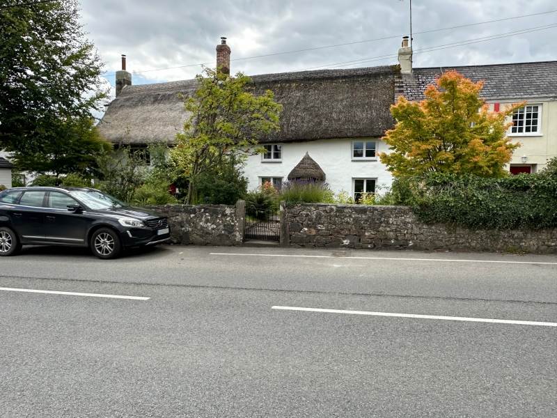
SAMPFORD COURTENAY STICKLEPATH
SX 69 SW
12/198 Taw Leat and Cottage adjoining
to left
GV II
Pair of cottages. Probably early C18. Rendered rubble and cob walls. Gable ended
thatch roof. Large projecting plastered rubble stack at left gable end, axial brick
stack between the 2 cottages.
Exterior: 2 storeys. Asymmetrical 4-window front; Taw Leat to the right has C20
replacement windows early-mid C19 6-panel door to right of centre under thatch
doorhood. Left-hand cottage has C19 small-paned casements of 4 and 2-lights to the
first floor and 3-light to the left on the ground floor. To the right on the ground
floor is a C20 single pane window. Identical door to Taw Leat.
Interior inaccessible at time of survey.
Plan: pair of 2-room plan cottages each with larger heated room to the left and
entry into smaller unheated room to the right.
Listing NGR: SX6430094041
External links are from the relevant listing authority and, where applicable, Wikidata. Wikidata IDs may be related buildings as well as this specific building. If you want to add or update a link, you will need to do so by editing the Wikidata entry.


Other nearby listed buildings
