Latitude: 51.1377 / 51°8'15"N
Longitude: 0.4322 / 0°25'55"E
OS Eastings: 570247
OS Northings: 140414
OS Grid: TQ702404
Mapcode National: GBR NRB.N2B
Mapcode Global: VHJMY.FNTQ
Plus Code: 9F324CQJ+3V
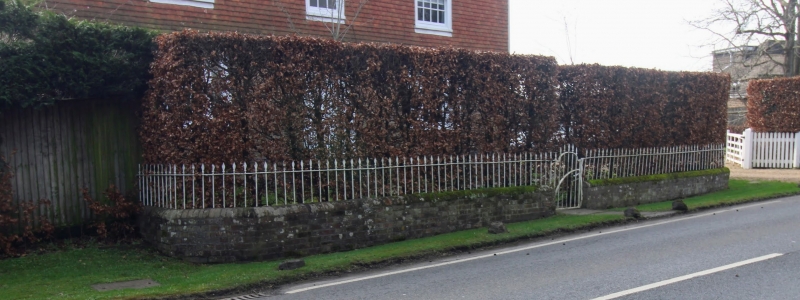
Entry Name: Wall and Railings Approximately 7 Metres North of Tanyard House
Listing Date: 10 October 1989
Last Amended: 14 May 1990
Grade: II
Source: Historic England
Source ID: 1105650
English Heritage Legacy ID: 169874
ID on this website: 101105650
Location: Horsmonden, Tunbridge Wells, Kent, TN12
County: Kent
District: Tunbridge Wells
Civil Parish: Horsmonden
Built-Up Area: Horsmonden
Traditional County: Kent
Lieutenancy Area (Ceremonial County): Kent
Church of England Parish: Horsmonden St Margaret
Church of England Diocese: Rochester
Tagged with: Wall
In the entry for:- HORSMONDEN GOUDHURST ROAD TQ 7040 7140 (south side) 7/38 Wall and Railings about 20 metres north of Tanyard House GV II
The entry shall be amended to read:-
TQ 7040 7140 HORSMONDEN GOUDHURST ROAD (south side) 7/38 Wall and Railings approx 7 metres north of Tanyard House GV II
------------------------------------
HORSMONDEN GOUDHURST ROAD TQ 7040-7140 (south side) 7/38 Wall and railings about 20 metres north of Tanyard House GV II
Wall and railings. Late C18. Red brick and wrought iron. Wall about 2-3 feet in height with coping, extending some 25 metres to left and to right of central single leaf iron gate, with simple spear headed rails about 3 feet in height on the wall. The left and right end sections of the wall are curved and returned towards Tanyard House.
Listing NGR: TQ7024740414
External links are from the relevant listing authority and, where applicable, Wikidata. Wikidata IDs may be related buildings as well as this specific building. If you want to add or update a link, you will need to do so by editing the Wikidata entry.


Other nearby listed buildings