Approximate Location Map
Large Map »
Latitude: 51.3647 / 51°21'52"N
Longitude: 1.0382 / 1°2'17"E
OS Eastings: 611591
OS Northings: 167227
OS Grid: TR115672
Mapcode National: GBR TX1.C9V
Mapcode Global: VHKJK.YY6Q
Plus Code: 9F33927Q+V7
Entry Name: 2 Cannon (Opposite No 9)
Listing Date: 20 May 1977
Grade: II
Source: Historic England
Source ID: 1106364
English Heritage Legacy ID: 170842
ID on this website: 101106364
Location: Tankerton, Canterbury, Kent, CT5
County: Kent
District: Canterbury
Electoral Ward/Division: Tankerton
Parish: Non Civil Parish
Built-Up Area: Whitstable
Traditional County: Kent
Lieutenancy Area (Ceremonial County): Kent
Tagged with: Building Cannon Architectural structure
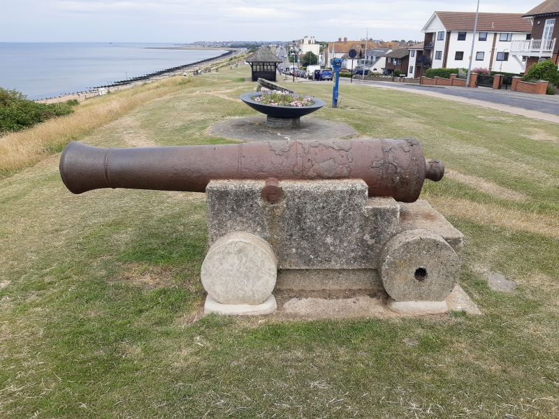
MARINE PARADE
1.
5273
(North Side)
Tankerton
2 Cannon
(opposite No 9)
TR 16 NW 4/149
II
2.
Late C18. 2 large iron cannons either side of flag pole towards the western end
of Marine Parade. Mounted on modern concrete bases with wheels in imitation of
carriage, probably from a ship of the line.
Listing NGR: TR1161167198
External links are from the relevant listing authority and, where applicable, Wikidata. Wikidata IDs may be related buildings as well as this specific building. If you want to add or update a link, you will need to do so by editing the Wikidata entry.


Other nearby listed buildings
