Latitude: 53.2251 / 53°13'30"N
Longitude: -1.7108 / 1°42'38"W
OS Eastings: 419402
OS Northings: 369820
OS Grid: SK194698
Mapcode National: GBR 467.SBK
Mapcode Global: WHCD6.P6JF
Plus Code: 9C5W67GQ+2M
Entry Name: The Elms
Listing Date: 12 July 1967
Last Amended: 27 July 1984
Grade: II
Source: Historic England
Source ID: 1109263
English Heritage Legacy ID: 80489
ID on this website: 101109263
Location: Ashford in the Water, Derbyshire Dales, Derbyshire, DE45
County: Derbyshire
District: Derbyshire Dales
Civil Parish: Ashford in the Water
Traditional County: Derbyshire
Lieutenancy Area (Ceremonial County): Derbyshire
Church of England Parish: Ashford-in-the-Water Holy Trinity
Church of England Diocese: Derby
SK 19 69 PARISH OF ASHFORD IN THE WATER VICARAGE LANE 11/59 (East Side) The Elms (formerly listed 12.7.1967 II as The Old Elms)
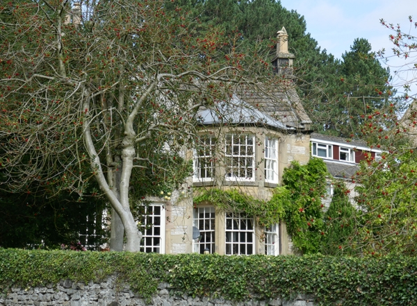
House. Early C19. Coursed limestone rubble. Gritstone dressings and quoins. Stone slate roof. Stone coped gables with plain kneelers. Stone gable end and ridge stacks with plain bands. Two storeys, lower section to north, double pile plan. Irregular four window street front. 3-light flush mullion windows with small pane casements to north. To south, two glazing bar sashes in flush surrounds. Beyond, flush doorcase with bracketed moulded stone hood. Panelled door with top two panels glazed, Over door to south, 3-light flush mullion window with small pane casements. To north, and higher up, 2-light flush mullion windows, To north again, two glazing bar sashes in flush surrounds. Garden elevation has two storey canted bay window to east with glazing bar sashes.
Listing NGR: SK1940269820
External links are from the relevant listing authority and, where applicable, Wikidata. Wikidata IDs may be related buildings as well as this specific building. If you want to add or update a link, you will need to do so by editing the Wikidata entry.


Other nearby listed buildings